
Demonym(s) Miglianichesi Patron saint Saint Pantaleon Dialling code 0871 | Elevation 136 m (446 ft) Area 22 km² Local time Wednesday 12:21 AM Postal code 66010 | |
 | ||
Frazioni Cagialone, Cerreto, Cerreto superiore, Cerrone, Ciummare, Collemarino, Elcine, Foreste, Montupoli, Piane San Pantaleone, Quattro Strade, Valle Sant'Angelo Weather 12°C, Wind NW at 5 km/h, 92% Humidity | ||
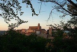
Miglianico is a town and comune of the Province of Chieti in the Abruzzo region of Italy.
Contents
- Map of 66010 Miglianico Province of Chieti Italy
- Geography
- History
- Sights
- Economy
- Famous People
- References
Map of 66010 Miglianico, Province of Chieti, Italy
Geography
Miglianico is situated in the foothills of the Italian Apennine Mountains.
History
During the Second World War, Miglianico was occupied by German forces attempting to hold ground as the American push by General Mark Clark advanced north from Southern Italy. Homes of residents were taken over by German units and used to quarter soldiers and served as command posts. Miglianico and the surrounding area was heavily damaged by Allied carpet bombing during 1944. Many of its residents fled to and lived in caves for months for safety.
Sights
It is home to two churches: the Church of St. Rocco and the Church of St. Pantaleone (the patron saint of the town). The Festival of St. Pantaleone is celebrated every year on 27 July, and is the patron saint of doctors and obstetricians.
Miglianico is also host to the Miglianico Tour foot race each year in August.
Economy
The town economy is predominately agricultural; wine grapes and olives are its primary crops.