
Prefecture Kanagawa Population 176,038 (Feb 2010) | Region Kantō Area 25.42 km² Local time Wednesday 4:33 AM | |
 | ||
Weather 7°C, Wind NW at 43 km/h, 54% Humidity Colleges and Universities Toyo Eiwa University, Yokohama Soei University | ||
Summuer matsuri festival tokaichiba midori ku yokohama kanagawa japan june 2015
Midori-ku (緑区) is one of the 18 wards of the city of Yokohama in Kanagawa Prefecture, Japan. As of 2010, the ward had an estimated population of 176,038 and a density of 6,900 persons per km². The total area was 25.42 km².
Contents
- Summuer matsuri festival tokaichiba midori ku yokohama kanagawa japan june 2015
- Map of Midori Ward Yokohama Kanagawa Prefecture Japan
- Geography
- Surrounding municipalities
- History
- Economy
- Railroads
- Highways
- Prefecture roads
- Education
- Noted people from Midori Ward
- Neighborhoods with Midori Ward
- References
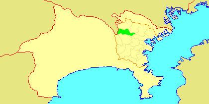
Map of Midori Ward, Yokohama, Kanagawa Prefecture, Japan
Geography
Midori Ward is located in eastern Kanagawa Prefecture, and on the northwest borders of the city of Yokohama. Except for the northeast portion, much of the area is hilly and relatively sparsely populated compared to other parts of the city. The flatter northeast portion is located on the Tsurumi River basin, with the river serving as a ward boundary with Tsuzuki-ku.
Surrounding municipalities
History
The area around present-day Midori Ward was formerly part of Tsuzuki District in Musashi Province. During the Edo period, it was a rural region classified as tenryō territory controlled directly by the Tokugawa shogunate, but administered through various hatamoto. After the Meiji Restoration, the area became part of the new Kanagawa Prefecture in 1868. In the cadastral reform of April 1, 1889, the area was divided into numerous villages. During the Meiji period, the area was a center for sericulture. On April 1, 1939, Tsuzuki District was annexed by the neighboring city of Yokohama. In a major administrative reorganization of October 1, 1969, Midori emerged as an independent ward within the city of Yokohama. In 1980, a portion of Midori Ward was transferred to Seya Ward. In 1994, Midori-ku was divided into the present-dau Midori-ku, and Aoba-ku and Tsuzuki-ku.
Economy
Midori Ward is largely a regional commercial center and bedroom community for central Yokohama and Tokyo. There is some residual agriculture in Midori Ward, primarily rice. Major industries include food processing, electronics and precision manufacturing.
Railroads
Highways
Prefecture roads
Education
Several universities are located in the ward, most notably the Nagatsuta campus of the Tokyo Institute of Technology. Other universities include Showa University and Toyo Eiwa University.
The Yokohama campus of the India International School in Japan is located in this ward.
Noted people from Midori Ward
Neighborhoods with Midori Ward
Areas with a -cho suffix are located in the less dense parts of the ward.