
Country United States County Niagara Time zone Eastern (EST) (UTC-5) Area 145 ha Zip code 14105 Area code Area code 716 | State New York FIPS code 36-46998 Elevation 160 m Population 1,806 (2013) Local time Tuesday 12:08 PM | |
 | ||
Weather 8°C, Wind W at 19 km/h, 61% Humidity | ||
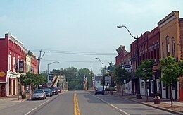
Life in the village middleport new york
Middleport is a village in Niagara County, New York, United States. The population was 1,840 at the 2010 census. The mail ZIP code is 14105. It is part of the Buffalo–Niagara Falls Metropolitan Statistical Area.
Contents
- Life in the village middleport new york
- Map of Middleport NY 14105 USA
- How to say or pronounce usa cities middleport new york
- History
- Geography
- Demographics
- References
Map of Middleport, NY 14105, USA
The Village of Middleport lies on the eastern edge of Niagara County, mostly inside the boundaries of the Town of Royalton, but a small part is within the Town of Hartland. Middleport is a port on the Erie Canal.
How to say or pronounce usa cities middleport new york
History
Settlers began moving into the area around 1808. The first store opened in the future village in 1822, before the canal reached the community.
The Erie Canal was opened along its entire length in 1825, and the community became an important location on the canal.
The village was formerly known as Tea-Pot Hollow before it was renamed Middleport.
The Village of Middleport was incorporated in 1872. The first election was held on March 22, 1859. The first meeting of the Board of Trustees was held on March 28, 1859.
The William Taylor House and U.S. Post Office are listed on the National Register of Historic Places.
Geography
Middleport is located at 43°12′42″N 78°28′33″W (43.211756, -78.475734).
According to the United States Census Bureau, the village has a total area of 0.9 square miles (2.3 km2), all of it land.
The village is located where north-south New York State Route 271 (Main Street) crosses east-west highways New York State Route 31 (Telegraph Road) and New York State Route 31E (State Street).
Demographics
As of the census of 2000, there were 1,917 people, 756 households, and 508 families residing in the village. The population density was 2,195.9 people per square mile (850.8/km²). There were 828 housing units at an average density of 948.5 per square mile (367.5/km²). The racial makeup of the village was 97.39% White, 0.83% African American, 0.26% Native American, 0.47% Asian, 0.26% from other races, and 0.78% from two or more races. Hispanic or Latino of any race were 1.77% of the population.
There were 756 households out of which 35.4% had children under the age of 18 living with them, 52.5% were married couples living together, 10.3% had a female householder with no husband present, and 32.7% were non-families. 27.6% of all households were made up of individuals and 13.9% had someone living alone who was 65 years of age or older. The average household size was 2.54 and the average family size was 3.11.
In the village, the population was spread out with 28.7% under the age of 18, 6.4% from 18 to 24, 29.3% from 25 to 44, 20.7% from 45 to 64, and 14.9% who were 65 years of age or older. The median age was 36 years. For every 100 females there were 90.0 males. For every 100 females age 18 and over, there were 87.5 males.
The median income for a household in the village was $36,464, and the median income for a family was $44,712. Males had a median income of $35,135 versus $22,500 for females. The per capita income for the village was $17,043. About 6.3% of families and 8.3% of the population were below the poverty line, including 7.1% of those under age 18 and 8.8% of those age 65 or over.