
 | ||
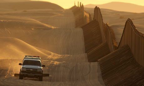
The Mexico–United States barrier is a series of walls and fences along the Mexico–United States border aimed at preventing illegal crossings from Mexico into the United States and vice versa. The barrier is not one continuous structure, but a grouping of relatively short physical walls, secured in between with a "virtual fence" which includes a system of sensors and cameras monitored by the United States Border Patrol. As of January 2009, U.S. Customs and Border Protection reported that it had more than 580 miles (930 km) of barriers in place. The total length of the continental border is 1,989 miles (3,201 km).
Contents
- Background
- Status
- Secure Fence Act
- Rethinking the expansion
- Expansion freeze
- Local efforts
- Trump administration
- Controversy
- Divided land
- Hidalgo County
- Mexico
- Migrant deaths
- Environmental impact
- References
Background
The barriers were built from 1994 as part of three larger "Operations" to taper transportation of illegal drugs manufactured in Latin America and immigration: Operation Gatekeeper in California, Operation Hold-the-Line in Texas, and Operation Safeguard in Arizona.
96.6 per cent of apprehensions by the Border Patrol in 2010 occurred at the southwest border. The number of Border Patrol apprehensions declined 61% from 1,189,000 in 2005 to 723,840 in 2008 to 463,000 in 2010. The decrease in apprehensions may be due to a number of factors including changes in U.S. economic conditions and border enforcement efforts. Border apprehensions in 2010 were at their lowest level since 1972.
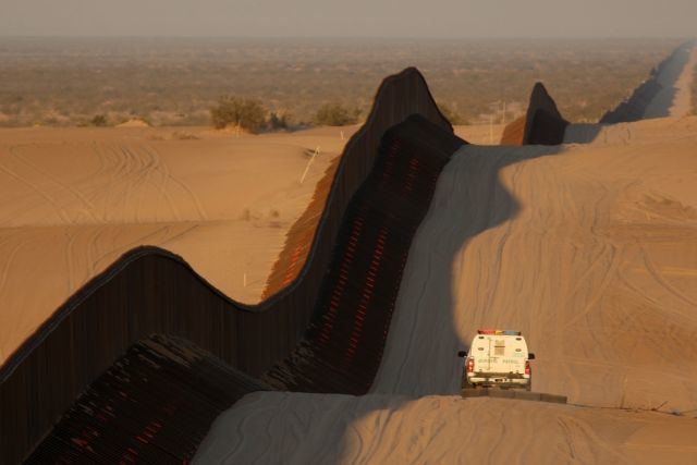
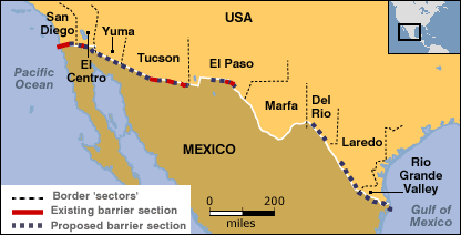
The 1,954-mile (3,145 km) border between the United States and Mexico traverses a variety of terrains, including urban areas and deserts. The barrier is located on both urban and uninhabited sections of the border, areas where the most concentrated numbers of illegal crossings and drug trafficking have been observed in the past. These urban areas include San Diego, California and El Paso, Texas. As of August 29, 2008, the U.S. Department of Homeland Security had built 190 miles (310 km) of pedestrian border fence and 154.3 miles (248.3 km) of vehicle border fence, for a total of 344.3 miles (554.1 km) of fence. The completed fence is mainly in New Mexico, Arizona, and California, with construction underway in Texas.
U.S. Customs and Border Protection reported that it had more than 580 miles (930 km) of fence in place by the second week of January 2009. Work is still under way on fence segments in Texas and on the Border Infrastructure System in California.
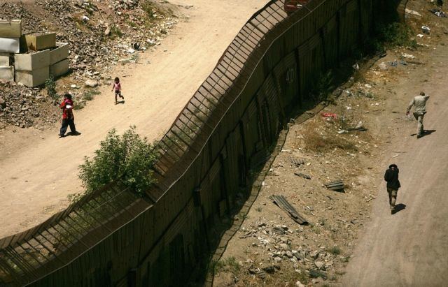
The border fence is not one continuous structure and is actually a grouping of short physical walls that stop and start, secured in between with "virtual fence" which includes a system of sensors and cameras monitored by Border Patrol Agents.
As a result of the effect of the barrier, there has been a marked increase in the number of people trying to illegally cross the Sonoran Desert and crossing over the Baboquivari Mountain in Arizona. Such illegal immigrants must cross 50 miles (80 km) of inhospitable terrain to reach the first road, which is located in the Tohono O'odham Indian Reservation.
Status
U.S. Representative Duncan Hunter, a Republican from California and the then-chairman of the House Armed Services Committee, proposed a plan to the House on November 3, 2005 calling for the construction of a reinforced fence along the entire United States–Mexican border. This would also have included a 100-yard (91 m) border zone on the U.S. side. On December 15, 2005, Congressman Hunter's amendment to the Border Protection, Anti-terrorism, and Illegal Immigration Control Act of 2005 (H.R. 4437) passed in the House. This plan called for mandatory fencing along 698 miles (1,123 km) of the 1,954-mile (3,145-km) border. On May 17, 2006 the U.S. Senate proposed with Comprehensive Immigration Reform Act of 2006 (S. 2611) what could be 370 miles (600 km) of triple layered-fencing and a vehicle fence. Although that bill died in committee, eventually the Secure Fence Act of 2006 was passed by Congress and signed by President George W. Bush on October 26, 2006.
The government of Mexico and ministers of several Latin American countries condemned the plans. Rick Perry, governor of Texas, also expressed his opposition saying that instead of closing the border it should be opened more and through technology support legal and safe migration. The barrier expansion was also opposed by a unanimous vote of the Laredo, Texas City Council. Laredo's Mayor, Raul G. Salinas, was concerned about defending his town's people by saying that the Bill which included miles of border wall would devastate Laredo. He stated "These are people that are sustaining our economy by forty percent, and I am gonna [sic] close the door on them and put [up] a wall? You don't do that. It's like a slap in the face." He hoped that Congress would revise the Bill to better reflect the realities of life on the border. There are no plans to build border fence in Laredo at this time. However, there is a large Border Patrol presence in Laredo.
Secure Fence Act
H.R. 6061, the "Secure Fence Act of 2006", was introduced on September 13, 2006. It passed through the U.S. House of Representatives on September 14, 2006 with a vote of 283–138.
On September 29, 2006, by a vote of 80–19 the U.S. Senate confirmed H.R. 6061 authorizing, and partially funding the "possible" construction of 700 miles (1,125 km) of physical fence/barriers along the border. The very broad support implied that many assurances were been made by the Administration—to the Democrats, Mexico, and the pro "Comprehensive immigration reform" minority within the GOP—that Homeland Security would proceed very cautiously. Secretary of Homeland Security Michael Chertoff, announced that an eight-month test of the virtual fence he favored would precede any construction of a physical barrier.
On October 26, 2006, President George W. Bush signed H.R. 6061 which was voted upon and passed by the 109th Congress of the United States. The signing of the bill came right after a CNN poll showed that most Americans "prefer the idea of more Border Patrol agents to a 700-mile (1,125-kilometer) fence." The Department of Homeland Security has a down payment of $1.2 billion marked for border security, but not specifically for the border fence.
As of January 2010, the fence project had been completed from San Diego, California to Yuma, Arizona. From there it continued into Texas and consisted of a fence that was 21 feet (6.4 m) tall and 6 feet (1.8 m) deep in the ground, cemented in a 3-foot (0.91 m)-wide trench with 5000 psi (345 bar; 352 kg/cm²) concrete. There were no fatalities during construction, but there were 4 serious injuries with multiple aggressive acts against building crews. There was one reported shooting with no injury to a crew member in Mexicali region. All fence sections are south of the All-American Canal, and have access roads giving border guards the ability to reach any point easily, including the dunes area where a border agent was killed 3 years before and is now sealed off.
The Republican Party's 2012 platform stated that "The double-layered fencing on the border that was enacted by Congress in 2006, but never completed, must finally be built." The Secure Fence Act's costs were estimated at $6 billion, more than the Customs and Border Protection's entire annual discretionary budget of $5.6 billion. The Washington Office on Latin America noted on its Border Fact Check site in about the year 2013 that the cost of complying with the Secure Fence Act's mandate was the reason it had not been completely fulfilled.
Rethinking the expansion
In January 2007 incoming House Majority Leader Steny H. Hoyer (D-MD) announced that Congress would revisit the fence plan, with committee chairs holding up funding until a comprehensive border security plan was presented by the United States Department of Homeland Security. Then the Republican senators from Texas, John Cornyn and Kay Bailey Hutchison, advocated revising the plan, as well.
The REAL ID Act, attached as a rider to a supplemental appropriations bill funding the wars in Iraq and Afghanistan, decreed, “Not withstanding any other provision of law, the Secretary of Homeland Security shall have the authority to waive all legal requirements such Secretary, in such Secretary’s sole discretion, determines necessary to ensure expeditious construction of the barriers and roads." Secretary Chertoff used his new power to “waive in their entirety” the Endangered Species Act, the Migratory Bird Treaty Act, the National Environmental Policy Act, the Coastal Zone Management Act, the Clean Water Act, the Clean Air Act, and the National Historic Preservation Act to extend triple fencing through the Tijuana River National Estuarine Research Reserve near San Diego. The Real ID Act further stipulates that the Secretary's decisions are not subject to judicial review, and in December 2005 a federal judge dismissed legal challenges by the Sierra Club, the Audubon Society, and others to Chertoff’s decision.
Secretary Chertoff exercised his waiver authority on April 1, 2008. In June 2008, the U.S. Supreme Court declined to hear the appeal of a lower court ruling upholding the waiver authority in a case filed by the Sierra Club. In September 2008 a federal district court judge in El Paso dismissed a similar lawsuit brought by El Paso County, Texas.
By January 2009, U.S. Customs and Border Protection and Homeland Security had spent $40 million on environmental analysis and mitigation measures aimed at blunting any possible adverse impact that the fence might have on the environment. On January 16, 2009, DHS announced it was pledging an additional $50 million for that purpose, and signed an agreement with the U.S. Department of the Interior for utilization of the additional funding.
Expansion freeze
On March 16, 2010, the Department of Homeland Security announced that there would be a halt to expand the "virtual fence" beyond two pilot projects in Arizona.
Contractor Boeing Corporation had numerous delays and cost overruns. Boeing had initially used police dispatching software that was unable to process all of the information coming from the border. The $50 million of remaining funding would be used for mobile surveillance devices, sensors, and radios to patrol and protect the border. At the time, the Department of Homeland Security had spent $3.4 billion on border fences and had built 640 miles (1,030 km) of fences and barriers as part of the Secure Border Initiative.
Local efforts
In response to a perceived lack of will on the part of the federal government to build a secure border fence, and a lack of state funds, Arizona officials plan to launch a website allowing donors to help fund a state border fence.
Piecemeal fencing has also been established. In 2005, under its president, Ramón H. Dovalina, Laredo Community College, located on the border, obtained a 10-foot fence built by the United States Marine Corps. The structure was not designed as a border barrier per se but was intended to divert smugglers and illegal immigrants to places where the authorities can halt entrance into the United States.
Trump administration
Throughout his 2016 presidential campaign, Donald Trump called for the construction of a much larger and fortified wall along the Mexico–United States border, and claimed Mexico will pay for its construction, estimated at $8 to $12 billion, while others state there are enough uncertainties to drive up the cost between $15 to $25 billion. In January 2017, Mexican President Enrique Peña Nieto said the country would not pay, and later compared then President-elect Trump's rhetoric to the former Dictator of Italy Benito Mussolini. On January 25, 2017, the Trump administration signed a Border Security and Immigration Enforcement Improvements Executive Order, 13767 to commence the building of the border wall. In response, Peña Nieto gave a national televised address confirming they would not pay, adding "Mexico doesn't believe in walls", and cancelled a scheduled meeting with Trump at the White House.
Controversy
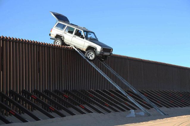
The barrier has been criticized for being easy to get around. Some methods include digging under it (sometimes using complex tunnel systems), climbing the fence (using wire cutters to remove barbed-wire) or locating and digging holes in vulnerable sections of the wall. Many Latin-Americans have also traveled by boat through the Gulf of Mexico or the Pacific Coast.
Divided land
Tribal lands of three indigenous nations would be divided by the proposed border fence.
On January 27, 2008, a U.S. Native American human rights delegation, which included Margo Tamez (Lipan Apache-Jumano Apache) and Teresa Leal (Opata-Mayo) reported the removal of the official International Boundary obelisks of 1848 by the U.S. Department of Homeland Security in the Las Mariposas, Sonora-Arizona sector of the Mexico–U.S. border. The obelisks were moved southward approximately 20 meters, onto the property of private landowners in Sonora, as part of the larger project of installing the 18-foot (5.5 m) steel barrier wall.
The proposed route for the border fence would divide the campus of the University of Texas at Brownsville into two parts, according to Antonio N. Zavaleta, a vice president of the university. There have been campus protests against the wall by students who feel it will harm their school. In August 2008, UT-Brownsville reached an agreement with the U.S. Department of Homeland Security for the university to construct a portion of the fence across and adjacent to its property. The final agreement, which was filed in federal court on Aug 5 and formally signed by the Texas Southmost College Board of Trustees later that day, ended all court proceedings between UTB/TSC and DHS. On August 20, 2008, the university sent out a request for bids for the construction of a 10-foot (3.0 m) high barrier that incorporates technology security for its segment of the border fence project. The southern perimeter of the UTB/TSC campus will be part of a laboratory for testing new security technology and infrastructure combinations. The border fence segment on the UTB campus was substantially completed by December 2008.
Hidalgo County
In the spring of 2007 more than 25 landowners, including a corporation and a school district, from Hidalgo and Starr County in Texas refused border fence surveys, which would determine what land was eligible for building on, as an act of protest.
In July 2008, Hidalgo County and Hidalgo County Drainage District No. 1 entered into an agreement with the U.S. Department of Homeland Security for the construction of a project that combines the border fence with a levee to control flooding along the Rio Grande. Construction of two of the Hidalgo County fence segments are under way; five more segments are scheduled to be built during the fall of 2008; the Hidalgo County section of the border fence will constitute 22 miles (35 km) of combined fence and levee.
Mexico
In 2006, the Mexican government vigorously condemned the Secure Fence act of 2006. Mexico has also urged the U.S. to alter its plans for expanded fences along their shared border, saying that it would damage the environment and harm wildlife.
In June 2007, it was announced that a section of the barrier had been mistakenly built from 1 to 6 feet (2 meters) inside Mexican territory. This will necessitate the section being moved at an estimated cost of over $3 million (U.S.).
In 2012, then presidential candidate of Mexico Enrique Peña Nieto was campaigning in Tijuana at the Playas de Monumental, less than 600 yards (550 m) from the U.S.–Mexico border adjacent to Border Field State Park. In one of his speeches he criticized the U.S. government for building the barriers, and asked for them to be removed. Ultimately, he mocked Ronald Reagan's "Tear down this wall!" speech from Berlin in 1987.
Migrant deaths
Between 1994 and 2007, there were around 5,000 Migrant deaths along the Mexico–United States border, according to a document created by the Human Rights National Commission of Mexico, also signed by the American Civil Liberties Union. Between 43 and 61 people died trying to cross the Sonoran Desert from October 2003 to May 2004; three times that of the same period the previous year. In October 2004 the Border Patrol announced that 325 people had died crossing the entire border during the previous 12 months. Between 1998 and 2004, 1,954 persons are officially reported to have died along the US-Mexico border. Since 2004, the bodies of 1,086 migrants have been recovered in the southern Arizona desert.
U.S. Border Patrol Tucson Sector reported on October 15, 2008 that its agents were able to save 443 undocumented immigrants from certain death after being abandoned by their smugglers, during FY 2008, while reducing the number of deaths by 17% from 202 in FY 2007 to 167 in FY 2008. Without the efforts of these agents, hundreds more could have died in the deserts of Arizona. According to the same sector, border enhancements like the wall have allowed the Tucson Sector agents to reduce the number of apprehensions at the borders by 16% compared with fiscal year 2007.
Environmental impact
In April 2008, the Department of Homeland Security announced plans to waive more than 30 environmental and cultural laws to speed construction of the barrier. Despite claims from then Homeland Security Chief Michael Chertoff that the department would minimize the construction's impact on the environment, critics in Arizona and Texas asserted the fence endangered species and fragile ecosystems along the Rio Grande. Environmentalists expressed concern about butterfly migration corridors and the future of species of local wildcats, the ocelot, the jaguarundi, and the jaguar.
U.S. Customs and Border Protection (CBP) conducted environmental reviews of each pedestrian and vehicle fence segment covered by the waiver, and published the results of this analysis in Environmental Stewardship Plans (ESPs). Although not required by the waiver, CBP has conducted the same level of environmental analysis (in the ESPs) that would have been performed before the waiver (in the “normal” NEPA process) to evaluate potential impacts to sensitive resources in the areas where fence is being constructed.
ESPs completed by CBP contain extremely limited surveys of local wildlife. For example, the ESP for border fence built in the Del Rio Sector included a single survey for wildlife completed in November 2007, and only "3 invertebrates, 1 reptile species, 2 amphibian species, 1 mammal species, and 21 bird species were recorded." The ESPs then dismiss the potential for most adverse effects on wildlife, based on sweeping generalizations and without any quantitative analysis of the risks posed by border barriers. Approximately 461 acres (187 ha) of vegetation will be cleared along the impact corridor. From the Rio Grande Valley ESP: "The impact corridor avoids known locations of individuals of Walker's manioc and Zapata bladderpod, but approaches several known locations of Texas ayenia. For this reason, impacts on federally listed plants are anticipated to be short-term, moderate, and adverse." This excerpt is typical of the ESPs in that the risk to endangered plants is deemed short-term without any quantitative population analysis.
By August 2008, more than 90 percent of the southern border in Arizona and New Mexico had been surveyed. In addition, 80 percent of the California/Mexico border has been surveyed.