
Formed February 1, 2000 Affected area Madagascar | Dissipated February 29, 2000 | |
 | ||
Highest winds 10-minute sustained: 185 km/h (115 mph)
1-minute sustained: 215 km/h (130 mph) Lowest pressure 928 hPa (mbar); 27.4 inHg Areas affected Madagascar, much of southern Africa (mainly Mozambique) Date 1 February 2000 – 29 February 2000 Similar Cyclone Hudah, Cyclone Connie, Cyclone Japhet, Cyclone Favio, Cyclone John | ||
Cyclone Leon–Eline in February 2000 was the third-longest tracked tropical cyclone in the South-West Indian Ocean. On February 1, a tropical low originated within the monsoon trough to the south of Indonesia, and would eventually become Tropical Cyclone Leon in the Australian basin. Moving westward, the storm fluctuated in strength due to changes in the atmosphere, mostly increasing and decreasing wind shear. After crossing 90° E, the Météo-France office in Réunion (MFR) began tracking the system as Tropical Storm Eline on February 8. The storm continued across the Indian Ocean and intensified greatly as it approached the east coast of Madagascar. Late on February 17, Eline made landfall near Mahanoro, with 10‑minute winds of 165 km/h (105 mph). The storm rapidly weakened over land, but restrengthened in the Mozambique Channel to reach peak 10‑minute winds of 185 km/h (115 mph). On February 22, Eline made landfall about 80 km (50 mi) south of Beira, Mozambique near peak intensity and quickly weakened over land. The well-defined circulation moved across southern Africa, finally dissipating over eastern Namibia on February 29.
Contents
Eline was unusual in its track after striking Madagascar. Most storms in the Mozambique Channel turn to the south, ultimately missing land; however, upon landfall, Eline became one of 5% of recorded cyclones to strike southern Africa. In addition, favorable conditions allowed the storm to maintain its identity over land. Overall, Cyclone Leon–Eline traveled over 11,000 km (6,800 mi) during its 29–day duration.
Origins
The origins of Leon–Eline were from a low pressure area that developed within the monsoon trough on February 1 in the eastern Indian Ocean, about 250 km (155 mi) south of the Indonesian island of Bali. The low formed due to a surge of energy within the monsoon that had crossed the equator from the northwest. Associated convection, or thunderstorms, was initially sparse. Over the subsequent few days the system tracked west-southwestward without much development, moving around a large ridge over northwestern Australia. There was initially moderate wind shear in the region. However, a developing anticyclone allowed the convection to persist over the center and develop outflow. At 22:00 UTC on February 3, the Perth Tropical Cyclone Warning Center (PTCWC) upgraded the tropical low to a Category 1 on the Australian tropical cyclone scale, estimating 10‑minute sustained winds of 65 km/h (40 mph). At 04:00 UTC the next day, the PTCWC named the storm Tropical Cyclone Leon. On the same day at 03:00 UTC, the Joint Typhoon Warning Center (JTWC) began issuing advisories on the storm as Tropical Cyclone 11S. Around that time, the storm was located about 215 km (130 mi) south-southeast of Christmas Island.
After becoming a named storm, Leon turned more to the west-southwest, due to a trough weakening the ridge to the south. The storm developed increased convective banding, aided by decreasing wind shear, and quickly intensified. Early on February 5, the PTCWC upgraded Leon to a Category 3 on the Australian scale, estimating 10‑minute winds of 120 km/h (75 mph). At 22:00 UTC that day, the agency estimated an initial peak of 140 km/h (85 mph). On February 6, the cyclone developed an eye in the center of the convection that was only visible on Special sensor microwave/imager, not on satellite imagery. On the same day, the JTWC upgraded Leon to the equivalent of a minimal hurricane, estimating 1‑minute winds of 140 km/h (85 mph). A trough passing to the south increased wind shear, causing the storm to weaken. Around that time, Leon passed about 510 km (315 mi) south of the Cocos Islands, while turning more to the west after the ridge strengthened to the south. By February 8, the circulation was exposed from the rapidly dwindling thunderstorms. At 18:00 UTC that day, Leon crossed 90° E into the south-west Indian Ocean, and as result was renamed Eline by the Mauritius Meteorological Service. By that time, Météo-France (MFR) estimated 10‑minute winds of 65 km/h (40 mph).
Strengthening and first landfall
Over the subsequent few days, wind shear caused the convection to wax and wane over Eline's center, limiting the thunderstorms to the southern periphery. The track shifted more to the west-northwest. On February 11, Eline had weakened into a minimal tropical storm according to the MFR, about 1110 km (690 mi) south of Diego Garcia, and the JTWC operationally downgraded it to a tropical depression. Later that day, however, a decrease in shear allowed thunderstorms to refire. On February 13, a weakness in the ridge caused the storm to turn back to the west-southwest. Moving back beneath an anticyclone, conditions became more favorable for strengthening, allowing outflow and a central dense overcast to form, with the beginnings of an eye feature. Eline quickly intensified into a severe tropical storm late on February 13. At 00:00 UTC the next day, the JTWC upgraded Eline to the equivalent of a minimal hurricane with 1‑minute winds of 120 km/h (75 mph). The MFR held off upgrading the storm, due to a passing trough increasing wind shear again. On February 14, Eline passed about 85 km (55 mi) south of St. Brandon, and shortly thereafter resumed its strengthening after the shear dropped. Later that day, the storm bypassed Mauritius about 180 km (110 mi) to the northwest, with the small structure sparing the island from the strongest winds. Early on February 16, Eline attained tropical cyclone status, with 10‑minute winds of 120 km/h (75 mph), while passing about 160 km (100 mi) northwest of Réunion. This was nine days after it had weakened to tropical storm status the first time.
After becoming a tropical cyclone, Eline was still encountering wind shear and dry air. Despite these factors, the eye became better defined and the storm intensified, aided by favoring upper-level conditions. The cyclone turned more to the west toward Madagascar, despite a weakness in the ridge to the south. While approaching the country, Eline quickly intensified, reaching 10‑minute winds of 165 km/h (105 mph) by 18:00 UTC on February 17. Around that time, the cyclone made landfall on eastern Madagascar near Mahanoro. Eline rapidly weakened over land while moving to the west-southwest, and the JTWC downgraded the storm to tropical depression status within 18 hours of moving ashore.
Mozambique Channel and final landfall
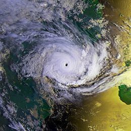
After crossing Madagascar for 26 hours, Eline emerged into the Mozambique Channel near Belo, still maintaining good outflow. With warm waters and a favorable upper level environment, the depression quickly re-intensified as convection increased. At 12:00 UTC on February 19, Eline re-attained moderate tropical storm status. While in the central Mozambique Channel, Eline passed about 35 km (20 mi) north of Europa Island, which recorded a barometric pressure of 992 mbar (29.3 inHg). Shortly thereafter, the storm turned more to the west-northwest due to a strengthening ridge to the south. A brief increase in wind shear delayed the strengthening trend, but Eline resumed intensifying on February 21 while slowly approaching southeastern Africa. Over a 24‑hour period, the pressure dropped by 45 mbar (1.3 inHg), indicative of rapid deepening. During that time, the convection organized into an intense eyewall around a well-defined 60 km (35 mi) eye. Eline had re-attained tropical cyclone at 12:00 UTC on February 21, and by 18 hours later reached intense tropical cyclone status. The MFR estimated peak 10‑minute winds of 185 km/h (115 mph); in contrast, the JTWC estimated peak 1‑minute winds of 215 km/h (130 mph), the equivalent of a Category 4 on the Saffir-Simpson hurricane scale. While at peak intensity, Eline made landfall about 80 km (50 mi) south of Beira, Mozambique, where a pressure of 989 mbar (29.2 inHg) was recorded. Gusts at landfall were estimated at 260 km/h (160 mph).
Although the winds rapidly decreased after landfall, the storm maintained a well-defined structure as it crossed from Mozambique into Zimbabwe late on February 22. Weakening to tropical depression status, Eline crossed Zimbabwe and maintained its circulation, entering Botswana on February 24. Three days later, the center drifted into eastern Namibia and turned to the south, dissipating on February 29. After the circulation dissipated, the residual system merged with a heat low and an approaching cold front.
Statistics
Throughout its duration, Leon-Eline lasted 29 days, a record longevity for a storm in the southern Indian Ocean. The track was over 11,000 km (6,800 mi), or about 25% of the Earth's circumference. However, Eline was in the south-west Indian Ocean for 21 days, which is the third most on record. It was behind Cyclone Alibera in 1989 and Cyclone Georgette in 1968, the latter of which lasted 24 days in the basin. The MFR noted that Eline was the strongest cyclone to strike the nation in several decades. The storm was uncommon in its landfall on mainland Africa; only 5% of storms in the basin do so, and most that cross or form in the Mozambique Channel turn to the south. Eline was unusual in maintaining its identity so far inland, aided by increased moisture and enhanced upper-level environmental conditions over southern Africa. The storm's long track brought heavy rainfall across Madagascar and southern Africa, causing additional widespread flooding.