
Elevation 4,462 ft (1,360 m) Mountain type Caliche | Prominence 200 ft (61 m) Age of rock Quaternary | |
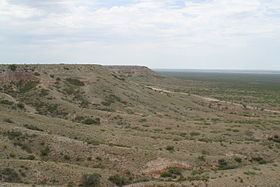 | ||
The Mescalero Escarpment or Mescalero Ridge forms the western edge of the great Llano Estacado, a vast plateau or tableland in the southwestern United States in New Mexico and Texas. It is the western equivalent of the Caprock Escarpment, which defines the eastern edge of the Llano Estacado.
Contents
Map of Mescalero Escarpment, New Mexico 88203, USA
Mescalero Sands
Extending north-south along the western edge of the Mescalero Escarpment lies a vast sand sheet called the Mescalero Sands, named after the Mescalero Apaches who once hunted in these sandhills. In 1928, Nelson Horatio Darton of the United States Geological Survey observed: “On the east side of the Pecos Valley in southern New Mexico there are very extensive sand hills formed of deposits known as the ‘Mescalero Sands,’ which are doubtless of Quaternary age ...” In places, these sands climb up and over the Mescalero Escarpment and spread out over portions of the Llano Estacado.