
Prominence 158 m | Elevation 3,328 m | |
 | ||
Topo map USGS Boulder Chain Lakes Similar Castle Peak, Patterson Peak, Blackmon Peak, Mount Julius Caesar, Bear Creek Spire | ||
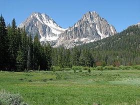
Merriam Peak, at 10,920 feet (3,330 m) is one of the peaks of the White Cloud Mountains of Custer County, Idaho. Merriam Peak is located in the middle of the range just north of Castle Peak, the highest point in the range. The peak is located in the White Clouds roadless area of Sawtooth National Recreation Area.
Map of Merriam Peak, Idaho 83227, USA
Merriam Peak is in the watershed of Little Boulder Creek, which is a tributary of the East Fork of the Salmon River. Castle Lake is at the peak's southern base, separating it from Castle Peak. Baker Lake is east of the peak, while Noisy and Quiet lakes are north and west of the peak, respectively.
References
Merriam Peak (Idaho) Wikipedia(Text) CC BY-SA