
Demonym(s) Meppeler Postcode 7940–7949, 7965–7969 Area 56.98 km² Area code 0522 | Elevation 2 m (7 ft) Time zone CET (UTC+1) Website www.meppel.nl Founded 1644 Local time Sunday 4:52 AM | |
 | ||
Weather 9°C, Wind SW at 16 km/h, 99% Humidity | ||
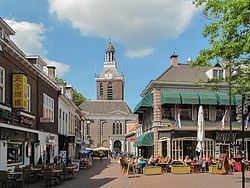
Meppel ( [ˈmɛpəl]) is a municipality and a city in the northeast of the Netherlands, in the south-west of the province Drenthe.
Contents
Map of Meppel, Netherlands
It developed in the 16th century as a transport and distribution inland harbour for turf. There used to be a lot of waterways in the town, but now only one remains.
People born in Meppel are occasionally referred to as 'Meppeler Muggen'; this translates as mosquitos/gnats from Meppel. This is due to a traditional folk tale. The people of Meppel thought the church tower was on fire. After closer inspection it was only a swarm of mosquitos.
Population centres
Broekhuizen, De Kolk, De Schiphorst, Havixhorst, Kolderveen, Kolderveense Bovenboer, Lindenhorst, Meppel, Nijentap, Nijeveen, Nijeveense Bovenboer, and Rogat.
Meppel
Meppel received city rights in 1644. It is the oldest town in the province of Drenthe.