
Width 3 km (1.9 mi) Highest point Meløytinden Area 21.8 km² | Length 11 km (6.8 mi) Highest elevation 582 m (1,909 ft) Municipality Meløy | |
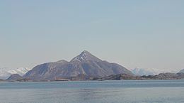 | ||
Meløya is an island in the municipality of Meløy in Nordland county, Norway. The island lies east of Bolga, north of Åmnøya, and west of Mesøya. The 21.8-square-kilometre (8.4 sq mi) island is only accessible by boat, and there are regular ferry connections to Bolga, Støtt, Vassdalsvik, and Ørnes.
Map of Meloya, 8157 Mel%C3%B8y, Norway
The western part of the island is relatively flat and has many farms. The village of Meløy is located in this area and it is the main population centre on the island. Meløy Church is located in the village of Meløy. The village of Meløy was the administrative centre of Meløy until 1952 when it was moved to Ørnes. The eastern part of the island is mountainous, and it is dominated by the 582-metre (1,909 ft) tall Meløytinden.
References
Meløya Wikipedia(Text) CC BY-SA