
Local time Saturday 6:47 AM | Area 16.7 km² | |
 | ||
Name meaning string (of a tent, reflected in logo) Weather 13°C, Wind NE at 8 km/h, 57% Humidity | ||
Meitar (Hebrew: מֵיתָר) is a small local council north-east of Beersheba, in Israel's Southern District. The town lies on Highway 60 just south of the Green Line on the southern edge of Mount Hebron, alongside the Yatir Forest. Metar is 19 km north of Beer-Sheva and is in between the two Bedouin towns of Hura and Laqiya. In 2015 it had a population of 7,341.
Contents
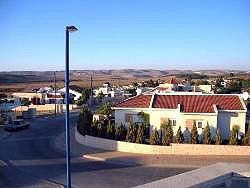
Map of Meitar, Israel
With a land area of 16,696 dunams (~16.7 km²), Meitar is ranked very highly on the Israeli socio-economic scale, with a score of 9/10.
History
Meitar was founded in 1984. The area drew national attention during the Shai Dromi trial.
References
Meitar Wikipedia(Text) CC BY-SA