
Peak Kawagebo Area 6,000 km² | State Yunnan Elevation 6,740 m Country China | |
 | ||
Length 200 km (120 mi) North-south Width 30 km (19 mi) East-west Settlement Deqen is the closest settlement of considerable size Mountains Mianzimu, Meili Snow Mountain Similar Kawagarbo, Yubeng Village, Tiger Leaping Gorge, Feilai Temple (Naka Zh, Jade Dragon Snow Mo | ||
such great heights by the postal service yunnan s meili snow mountains
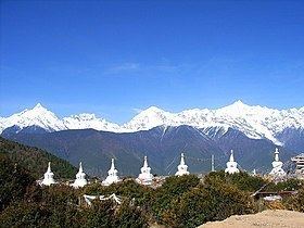
Meili Xue Shan (Chinese 梅里雪山, translation: "Mainri snowy range") or Mainri Snow Mountain (Tibetan: སྨན་རི།) is a mountain range in the Chinese province of Yunnan. It lies close to the northwestern boundary of the province and is bounded by the Salween River on the west and the Mekong on the east. The Meili are subrange of the larger Nu Mountains, themselves a constituent range of the Hengduan group. The crest of the range rises to over 6,000 metres (20,000 ft) above sea level, making for impressive prominence over the river valleys to the east and west, which are between 1,500 metres (4,900 ft) and 1,900 metres (6,200 ft) in elevation. The highest peak is Kawagebo, which rises to 6,740 metres (22,110 ft). Kawagebo is considered sacred for Tibetan Buddhists. Other significant peaks include Mianzimu, Cogar Laka and Jiariren-an. Because of restrictions and dangerous conditions, none of the major peaks in the range have ever been summited. In January 1991, six Chinese and eleven Japanese mountaineers lost their lives to an avalanche, one of the worst climbing accidents in China.
Contents
- such great heights by the postal service yunnan s meili snow mountains
- Map of Moirig Snow Mountain Deqen China
- References