
Area 955 km² | Width 30 km (19 mi) Population Uninhabited Max length 48 km | |
 | ||
Island groups Canadian Arctic Archipelago, Queen Elizabeth Islands | ||
Meighen Island is an uninhabited member of the Queen Elizabeth Islands, part of the Canadian Arctic Archipelago, in the Qikiqtaaluk Region of Nunavut, Canada.
Contents
- Map of Meighan Island Baffin Unorganized NU Canada
- Features and history
- Naming
- Neighbouring islands
- References
Map of Meighan Island, Baffin, Unorganized, NU, Canada
Features and history
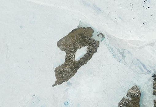
Located at 79°55'N 99°30'W, it measures 955 km2 (369 sq mi) in size and is topped with an ice cap. The island is continuously icebound, and its northwestern coast faces onto the open Arctic Ocean.
Unlike many Canadian Arctic islands, no traces of Inuit or Thule camps have been found, suggesting the island has never been inhabited, likely due to its extreme northern latitude.
The first known sighting of the island was in 1916, during the Canadian Arctic Expedition by Vilhjalmur Stefansson or perhaps by Frederick Cook in 1909.
Naming
The island was later named after Arthur Meighen, Canadian prime minister 1920-21 and 1926.
Neighbouring islands
Meighen Island has few neighbours. It is about 40 km (25 mi) west of the next nearest major island, Axel Heiberg Island. About 4 km (2.5 mi) to Meighen's north, across the Hose Strait, lies small crescent-shaped Perley Island. The Fay Islands lie between Meighen Island and Axel Heiberg Island within the Sverdrup Channel.