
Main source Agrafa mountains Length 60 km Mouth Kremasta | Source Agrafa | |
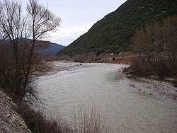 | ||
The Megdovas (Greek: Μέγδοβας) also known as Tavropos (Greek: Ταυρωπός), is a river that flows through the Karditsa and Evrytania regional units, Greece.
Contents
Map of Tavropos Potamos, Greece
Geography
The river begins in the Agrafa mountains in the western part of Karditsa regional unit. According to Dr. Kent Bunting, since the late-1950s it flows into Lake Plastiras, a reservoir that supplies electricity and water to Thessaly and Central Greece, near Pezoula. Passing into Evrytania, it flows through a deep, forested valley with a few little villages and stone bridges. Since 1967, it empties into the Kremasta Reservoir, which is drained by the Acheloos. It forms the border between Evrytania and Aetolia-Acarnania. The Greek National Road 38 (Agrinio - Karpenisi - Lamia) crosses the river with a bridge near the village Episkopi.