
 | ||
Meersel-Dreef is a village in the Belgian municipality of Hoogstraten. As of 2005, it has about 1,100 inhabitants.
Contents
- Map of 2328 Meersel Dreef Belgium
- About
- History
- Dreef
- Meersel
- Geography
- Recreation and nature
- Mobility
- References
Map of 2328 Meersel-Dreef, Belgium
Meersel-Dreef is the northernmost point of Belgium.
About
Meersel-Recherche consists of two settlements, which Meersel and Dreef.
The toponym Meersel is twofold, notably Lake and -sel. The word part is more derived from the Germanic word mari (more or mariski (land next to a watercourse). The word part -sel is supposedly derived from the Germanic word that means sali house.The name Meersel can thus be explained as a cottage in a low-lying area near a watercourse or house near a lake or swamp.
A la Recherche is another word for a drift. These were country roads along which they drove the cattle from the village to an open field.History
Meersel long remained very rural. Further north, on the border with the Netherlands developed a new hamlet la Recherche was strongly built and also the center of the joint parish Meersel-Recherche was. The construction of settlements has grown closer together so that the two villages now be mistaken for a village named Meersel-Drive. When the merger of Meerle Hoogstraten and they chose to merge Meersel and Drove to Meersel-Drive.In Meersel-Recherche is also the northernmost point of Belgium.
Dreef
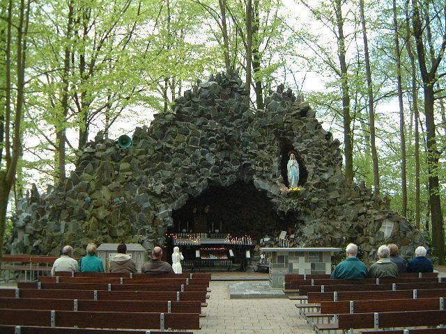
Dreef developed around the Capuchin Monastery, which was built in 1687 near the mark. The monastery serves as a parish church for the parish Meersel-Recherche and the monastery itself serving since 1968 as kapelanij. In 1889 a beech lane was constructed to the monastery. The Recherche, which has been protected since 1953, gave its name to the village that grew up around. Furthermore, as a monument recognized Maria Park (pilgrimage) and the Meersel Mill, a water mill on the river Mark, dating from the 14th century.
Meersel
The name Meersel was first mentioned as Meersele, meaning space for a pond. Spread was already inhabited around the year 1200. These people came from more. Is spread over Meerle which was mined from Baarle. There was as a street village along the road Leuven Breda. Spread was early spread the glories More (owned by the Lord of the Lake) and Meerle (owned by the abbey of Thorn) and this would not change during the entire Middle Ages. The hamlet remained divided in the development of the municipalities in 1795 the two municipalities.In 1223 was already built a chapel to Meersel. In 1421 a new chapel was built by the Lord of Hoogstraten. This chapel, St. Lucia chapel, was inaugurated on April 28 of that year and served as auxiliary chapel of the Church of Meerle. Until today, the chapel is a popular pilgrimage site. In 1935 and in 1982 it was restored and the chapel was classified in 1953 as a protected monument. Geography
Geography
The village is located at the Mark. It lies between Galder and Great Eysel. It is also the most northerly village in Belgium.
Recreation and nature
It's located near the Recreation De Mosten and Markdal.
Mobility
The transport company Arriva provides the connection of the district with Breda by bus number 145: Breda - the Klokkenberg - Meersel-Dreef.
The Flemish transport company 'De Lijn' provides the connection with a regular bus line from Turnhout, number 430. road traffic
De Vlaamse Vervoermaatschappij "De Lijn" verzorgt de verbinding met één reguliere buslijn vanuit Turnhout, nummer 430. Wegverkeer