
- elevation 8,300 ft (2,530 m) - elevation 6,234 ft (1,900 m) | - elevation 2,400 ft (732 m) Source Rubicon Lake | |
 | ||
Meeks Creek is a western tributary of Lake Tahoe which has its source on Rubicon Lake, 1.2 miles (1.9 km) northeast of Phipps Peak in Desolation Wilderness, trends northwest through Stony Ridge Lake, Shadow Lake, Crag Lake, and Lake Genevieve 3.5 miles (5.6 km), continues northeast 3.5 miles (5.6 km) to Meeks Bay on Lake Tahoe. At its mouth is the tiny town of Meeks Bay, California, in El Dorado County, California, United States.
Contents
Map of Meeks Creek, California, USA
HistoryEdit
The stream and bay are named for John Meeks, who owned the land. The Meeks brothers bailed 25 tons of wild hay in the meadows at the mouth of Meeks Creek in 1862.
EcologyEdit
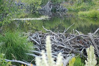
North American beaver (Castor canadensis) are gradually restoring Meeks Meadow which had been overgrown with coniferous trees. This meadow is an important wildflower viewing area and is easy to access as the trail starts across from Meeks Bay Resort. Mallow, iris, meadow aster, buckwheat, wandering daisy, yarrow, yampah, phlox, scarlet gilia, monkshood, flax and lupine are just some of the flowers that one can see in bloom during the peak flowering time in late June–July. A recent study of nearby Taylor Creek and Ward Creek showed that beaver dams increased wetland habitat, and decreased nutrients and sediments entering Lake Tahoe - all factors which positively impact the clarity of the lake's water. The Washo people, who lived in the eastern Sierra with hunting grounds extending as far west as Calaveras County, have a word for beaver, c'imhélhel.
RecreationEdit
The Meeks Bay trail follows Meeks Creek, beginning just north of the California State Route 89 bridge over the stream. The first 1.4 miles is along a gentle gated road and parallels Meeks meadow, which after an additional mile meets a trail that courses southwest eventually meeting the Pacific Crest Trail between Phipps Peak and Middle Velma Lake. The total trail length to Rubicon Lake is 8 miles (13.33 km); to Stony Ridge Lake 6.3 miles; to Shadow Lake 5.9 miles; to Hidden Lake 5.7 miles; to Crag Lake 5 miles; to Genevieve Lake 4.5 miles. Crag Lake is a popular day trip goal and swimming lake.
The lower 1.8 miles of trail are also excellent for snowshoeing (3.6 miles round trip and 1,000 feet elevation gain).