
Length 269 km | Source elevation 1,939 m | |
 | ||
Basin size 2,338 square miles (6,060 km) | ||
48 acres in wyoming along the little medicine bow river
The Medicine Bow River is a 167-mile-long (269 km) tributary of the North Platte River, in southern Wyoming in the United States.
Contents
- 48 acres in wyoming along the little medicine bow river
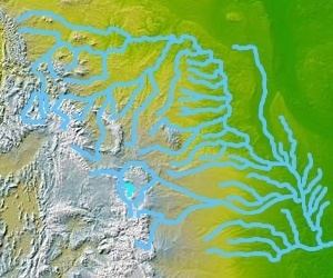
- Map of Medicine Bow River Wyoming USA
- References
Map of Medicine Bow River, Wyoming, USA
It rises in the Snowy Range, flowing out of the North Gap Lake, in southeastern Carbon County. It flows north, past Elk Mountain, then northeast, then northwest past the town of Medicine Bow and between the Shirley Mountains to the north and the Medicine Bow Mountains to the south. Near the town of Medicine Bow the Medicine Bow River is joined by its two largest tributaries, Rock Creek and the Little Medicine Bow River. It joins the North Platte in the Seminoe Reservoir, with the lower 10 miles (16 km) of the river forming an arm of the reservoir.
References
Medicine Bow River Wikipedia(Text) CC BY-SA