
Tehsil 16 | Tehsils 16 | |
 | ||
Colleges and Universities Indian Institute of Technology Hyderabad Points of interest Destinations Hyderabad, Medak, Sangareddi, Zaheerabad, Siddipet | ||
Medak district is a district located in the Indian state of Telangana. Medak is the district headquarters.
Contents
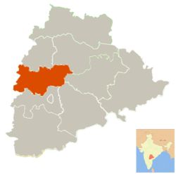
- Map of Medak Telangana
- History
- Nizam state
- Geography
- Demographics
- Economy
- Administrative divisions
- Mandals
- References
Map of Medak, Telangana
History
Traces of Neolithic and Megalithic culture was found at Edithanur and Wargal village hillocks in the district. Rock paintings were found at Edithanur boulders and Hastallapur rocks.
Nizam state
In 20th century Medak district was a part of Nizam princely State before independence and merged into Hyderabad State in Independent India and presently a district of Telangana. Qutub Shahis named it as Gulshanabad which means "city of gardens" due to its luscious greenery. The district is currently a part of the Red Corridor.
Geography
The district is spread over an area of 2,740.89 square kilometres (1,058.26 sq mi).
Demographics
As of 2011 Census of India, the district has a population of 767,428.
Economy
In 2006 the Indian government named Medak one of the country's 250 most backward districts (out of a total of 640). It is one of the thirteen districts in Andhra Pradesh currently receiving funds from the Backward Regions Grant Fund Programme (BRGF).
Administrative divisions
The district is divided into two revenue divisions of Medak, Narsapur and Tupran. These are sub-divided into sixteen mandals and has 381 villages. Bharathi Hollikeri is the present collector of the district.
Mandals
The below table categorizes 16 mandals into their respective revenue divisions in the district: