
Country India District West Siang district ISO 3166 code IN-AR Elevation 1,240 m | State Arunachal Pradesh Time zone IST (UTC+05:30) Vehicle registration AR | |
 | ||
Iaf c 17 lands at mechuka arunachal pradesh
Mechuka also known as Menchukha is a small town nestled 6,000 feet (1,829 m) above sea level in the Mechuka Valley in West Siang District of Arunachal Pradesh, India. Name of current MLA (October-2016) of Basar constituency is Pasang Dorjee Sona.
Contents
- Iaf c 17 lands at mechuka arunachal pradesh
- Map of Mechuka Village 791003
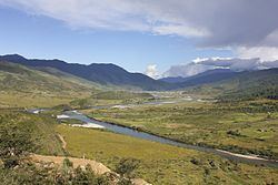
- Boating over the siyom river in mechuka arunachal pradesh
- Location
- Etymology
- History
- Demographics
- Religion
- Mechuka Airport
- Highways
- Tourism
- References
Map of Mechuka Village 791003
Boating over the siyom river in mechuka arunachal pradesh
Location
Menchukha is situated in a forested valley, surrounded by pine trees and thornbushes. The river Yargyapchu flows in the valley of Menchukha. Mechuka is 180 kilometres northwest of Along and is only 29 kilometres away from Indo-China border. The nearest airport is Lilabari Airport in Assam.
Etymology
The name Men-chu-kha means medicinal water of snow where men is medicine, chu is water and kha is snow though kha also means mouth. The popular name for Menchukha is Menchukha.
History
Prior to the construction of the modern road, the only access to the village was via an airstrip, used by the Indian Air Force to supply the local people.
Demographics
Menchukha Valley is home to the people of the Memba, Ramo, Bokar Libo tribes and Tagin tribes. The local population is primarily Memba, a Tibeto-mongloid Ethnic Group. Name of current MLA (August-2016) of Mechuka constituency is Pasang Dorjee Sona.
Religion
People of this place are believers of Buddhism, Donyi-Poloism, Christianity and speak Memba, Adi,Tagin language (Tagin) Hindi and English. Menchukha is known for both its religious and historical significance. The 400-year-old Samten Yongcha monastery of Mahayana Buddhist sect is a contemporary of the much-revered Tawang Monastery.
Mechuka Airport
The Indian Air Force maintains an airstrip, known as the Advanced Landing Ground (ALG) in Menchukha. The airstrip, being upgraded to a concrete runway, is used frequently to bring in vital supplies from cities in Assam via Antonov-32 aircraft and helicopters. The runway is under construction & shall be operational by mid of next year. The area has a significant military presence, which also creates some employment opportunities for civilians.
Highways
Menchukha has recently been connected by road to Along, the district headquarters about 200 km away, leading to increased development in the area. Menchukha has since become a subdivisional headquarters.
The 2,000-kilometre-long (1,200 mi) proposed Mago-Thingbu to Vijaynagar Arunachal Pradesh Frontier Highway along the McMahon Line, (will intersect with the proposed East-West Industrial Corridor Highway) and will pass through Mechuka, alignment map of which can be seen here and here.
Tourism
Menchukha is gradually becoming a popular tourist destination in Arunachal Pradesh due to its scenic beauty, exotic tribes, gentle hills and snow-capped mountains and River Siyom (locally known as Yargyap Chu). The Siom River, which flows through Menchukha also provides a scenic view in the valley.
The major tourist attraction here is a 400-year-old Buddhist Monastery, which is located at a hilltop in the westernmost part of Menchukha. Numerous ancient statues can also be found here. Accommodations are available at Tourist lodges and Inspection Bungalow and a few hotels are also coming up to meet the increasing influx of tourists from the country and abroad. The people of Ramo (Adi) tribe have resided in the Menchukha valley since time immemorial in the periphery of Menchukha valley in the villages of Gapo, Pauk, Padusa, Lipusi, Hiri, Purying, Rapum, Charung, Rego and Kart gumjipang, barang gang,shorang dhem, etc., , ,