
- elevation 1,190 ft (363 m) Basin area 167.3 km² | - length 2 mi (3 km) - elevation 1,154 ft (352 m) | |
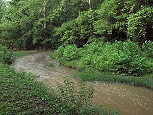 | ||
The Meathouse Fork is a tributary of Middle Island Creek, 19.7 miles (31.7 km) long, in north-central West Virginia in the United States. Via Middle Island Creek and the Ohio River, it is part of the watershed of the Mississippi River, draining an area of 64.6 square miles (167 km2) in a rural region on the unglaciated portion of the Allegheny Plateau.
Map of Meathouse Fork, West Virginia, USA
The Meathouse Fork's entire course and watershed are in southern and central Doddridge County. It is formed in southeastern Doddridge County by the confluence of Big Isaac Creek, 2 miles (3.2 km) long, which rises approximately 1 mile (1.6 km) southeast of the community of Miletus and flows southeastward; and Laurel Run, 1.6 miles (2.6 km) long, which rises approximately 0.75 miles (1.21 km) northeast of the community of Big Isaac and flows westward, through Big Isaac. From this confluence, approximately 0.9 miles (1.4 km) west of Big Isaac, the Meathouse Fork flows generally northwestward, through the unincorporated communities of Avon, New Milton, Sugar Camp, and Blandville, to Smithburg, where it joins Buckeye Creek to form Middle Island Creek.
The Meathouse Fork collects its largest tributary, Toms Fork, at Sugar Camp. In the vicinity of Sugar Camp and Blandville, it is paralleled by West Virginia Route 18.