
- right North Fork McWay Creek - elevation 100 ft (30 m) | - elevation 3,000 ft (914 m) | |
 | ||
- left Middle Fork McWay Creek, South Fork McWay Creek - location Waterfall Cove, California | ||
McWay Creek is a 2.5-mile-long (4.0 km) coastal stream in Monterey County in the U.S. state of California. It flows steeply west and south from McWay Canyon, high in California's Central Coast Range, and spills into the Pacific Ocean at Waterfall Cove after flowing over scenic McWay Falls. Most of the creek and its watershed are contained within Julia Pfeiffer Burns State Park, 12 miles (19 km) south of Pfeiffer Big Sur State Park. The creek is named after Christopher McWay from New York, a pioneer who homesteaded the property.
Contents
A Pelton wheel was installed in McWay Creek and generated power for Saddle Rock Ranch, the only electricity in the area for many years. The creek and its canyon are rich in vegetation types, due to the humid coastal climate with frequent fog and rainfall.
GeographyEdit
McWay Creek is formed by the confluence of its North and Middle Forks, at an elevation of roughly 1,270 feet (390 m). The North Fork is the longer of the two streams, beginning at an elevation of 3,450 feet (1,050 m), and running in a straight course southward to where it joins the Middle Fork. The smaller Middle Fork begins at an elevation of 3,182 feet (970 m) and flows south-southwest to meet the North Fork and form the mainstem of McWay Creek. After the mainstem is formed, the creek winds south and west through a narrow canyon to where it meets the South Fork at an elevation of roughly 400 feet (120 m).
The South Fork, the largest sub-basin in the McWay Creek watershed, begins at an elevation of 2,559 feet (780 m) on the east side of a ridge that separates it from the mainstem. After flowing south and turning slightly in a south-southwest direction, it meets McWay Creek. The creek then heads southwest, passing a parking area for Julia Pfeiffer Burns State Park and crossing under California's Highway 1 via a concrete culvert. It spills into the Pacific Ocean at Waterfall Cove.
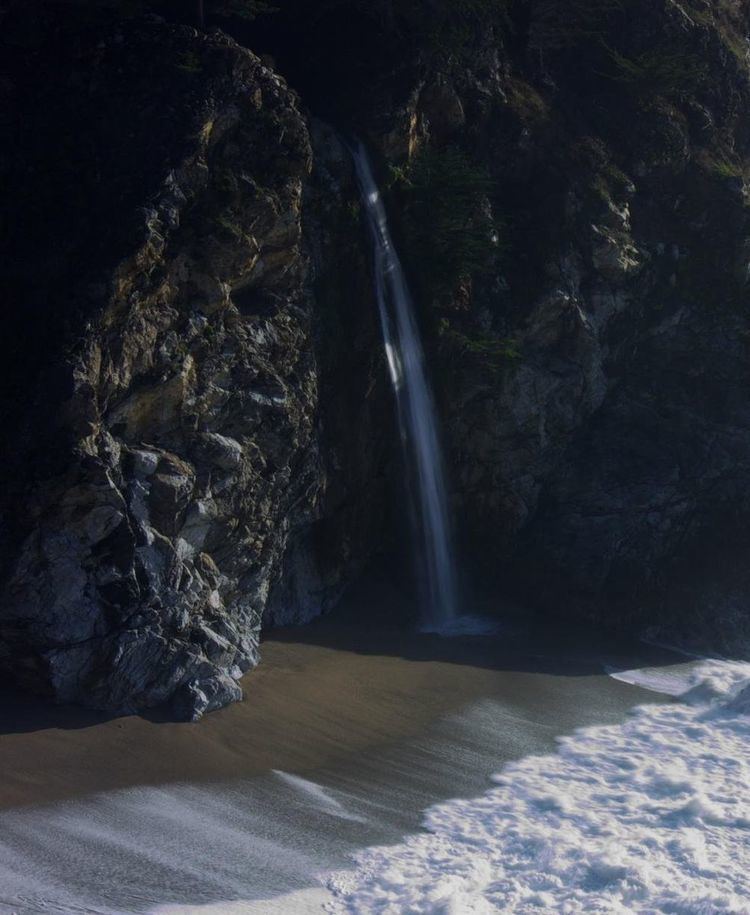
There are a number of waterfalls in the basin of McWay Creek. The most well-known is McWay Falls, which spills 80 feet (24 m) onto a sandy beach at Waterfall Cove. A smaller waterfall, the two-tier, 30-foot (9.1 m) McWay Creek Falls is located upstream of the Highway 1 culvert and the parking area. A small 30-foot (9.1 m) cascade, Canyon Trail Falls, is fed by the South Fork just before it meets McWay Creek. As most of the creek is steep and rocky, there are many unnamed waterfalls that also exist. McWay Creek is fed by a number of springs in McWay Canyon and flows year round.
HistoryEdit
Christopher McWay homesteaded the canyon named after him in the late 1870s. In 1924, Lathrop and Hélène Hooper Brown purchased the Saddle Rock Ranch totalling 1,600 acres from McWay, and Julia Pfieffer Burns, another Big Sur pioneer, leased land for cattle operations. Hélène became a good friend of Julia until Julia died in 1928. The Browns had a Pelton wheel installed in McWay Creek to generate electricity for the ranch.
BiologyEdit
The humid coastal climate of Big Sur and the McWay Canyon area supports a wide variety of vegetation in McWay Canyon. By the coast, the most prominent riparian vegetation consists of willows, alders, western coltsfoot and elk clover, with other species also existing among the dominant plants. Redwood trees also exist in McWay Canyon, but due to salty ocean air, it is said that the ones closer to the shore have not survived healthily. Coastal sage scrub is the dominant ground cover, specked by monkey flowers, Indian paintbrush, common yarrow, blue blossom and coast morning glory.
Upstream, oaks and bay trees begin to take presence. Ground cover consists of mostly sword fern, gooseberry, western wake robin and redwood sorrel. Forest clearings, found near higher elevations, consist of hedge nettle, bracken fern, and wild iris. Redwoods are still prevalent in the upstream areas of the watershed with one rumored to be the largest in the Big Sur area. As elevations increase, live oak, chamise and Coulter pine begin to make presence.