
Elevation 3 m | Area codes 415/628 Local time Thursday 2:57 PM | |
 | ||
Weather 21°C, Wind SW at 5 km/h, 55% Humidity | ||
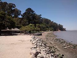
McNears Beach (formerly, McNear, McNear Landing, and McNear's Beach) is an unincorporated community on San Pablo Bay in Marin County, California.
Contents
Map of McNears Beach, CA 94901, USA
It is located 0.5 miles (0.8 km) north-northwest of Point San Pedro, and 3.4 miles (5.4 km) northeast of San Rafael. It is at an elevation of 10 feet (3 m). The community is in ZIP code 94901 and area codes 415 and 628.
History
McNears Beach developed a fishing industry in the 1870s. The McNear post office operated from 1897 to 1910. The name comes from the McNear Family, former owners of the land. The McNear Brothers, E.B. and J.A., moved to the beach site about 1870 and built two houses (which have since been demolished), a stable, a warehouse, and a general store.
McNears Beach Park
In 1970, the County acquired 55 acres at McNears Beach to create McNears Beach Park. Today, McNears Beach Park is a regional park offering a fishing pier, swimming pool, snack bar, sand volleyball court, picnic areas, and tennis courts.
The McNear Brothers stable remains, and is now used as a Park Ranger Office operated by Marin County Department of Parks and Open Space.
China Camp State Park, adjacent to McNear Beach on the east, is a unit of the San Francisco Bay National Estuarine Research Reserve.