
Country United States FIPS code 39-45822 Elevation 211 m Population 1,808 (2013) Area code 740 | Time zone Eastern (EST) (UTC-5) GNIS feature ID 1061495 Zip code 43756 Local time Thursday 9:59 AM | |
 | ||
Weather -3°C, Wind W at 16 km/h, 55% Humidity Area 4.921 km² (4.636 km² Land / 28 ha Water) | ||
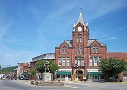
McConnelsville is a village in Morgan County, Ohio, United States. The population was 1,784 at the 2010 census. It is the county seat of Morgan County. As of October 19, 2011, the mayor is John Walter Finley.
Contents
Map of McConnelsville, OH 43756, USA
History
McConnelsville was laid out in 1817, and named after Robert McConnell, the original owner of the town site.
Geography
McConnelsville is located at 39°38′56″N 81°51′7″W (39.648915, −81.851954). It is on the east bank of the Muskingum River, opposite Malta.
According to the United States Census Bureau, the village has a total area of 1.90 square miles (4.92 km2), of which 1.79 square miles (4.64 km2) is land and 0.11 square miles (0.28 km2) is water.
2010 census
As of the census of 2010, there were 1,784 people, 765 households, and 404 families residing in the village. The population density was 996.6 inhabitants per square mile (384.8/km2). There were 870 housing units at an average density of 486.0 per square mile (187.6/km2). The racial makeup of the village was 93.3% White, 2.4% African American, 0.7% Native American, 0.4% Asian, 0.6% from other races, and 2.6% from two or more races. Hispanic or Latino of any race were 1.3% of the population.
There were 765 households of which 24.2% had children under the age of 18 living with them, 36.9% were married couples living together, 12.2% had a female householder with no husband present, 3.8% had a male householder with no wife present, and 47.2% were non-families. 42.2% of all households were made up of individuals and 22.4% had someone living alone who was 65 years of age or older. The average household size was 2.17 and the average family size was 2.99.
The median age in the village was 47.1 years. 20.1% of residents were under the age of 18; 8.8% were between the ages of 18 and 24; 18.9% were from 25 to 44; 26.9% were from 45 to 64; and 25.4% were 65 years of age or older. The gender makeup of the village was 45.1% male and 54.9% female.
2000 census
As of the census of 2000, there were 1,676 people, 805 households, and 445 families residing in the village. The population density was 953.7 people per square mile (367.7/km²). There were 881 housing units at an average density of 501.3 per square mile (193.3/km²). The racial makeup of the village was 95.70% White, 1.49% African American, 0.48% Native American, 0.06% Asian, 0.42% from other races, and 1.85% from two or more races. Hispanic or Latino of any race were 0.24% of the population.
There were 805 households out of which 25.0% had children under the age of 18 living with them, 40.5% were married couples living together, 11.4% had a female householder with no husband present, and 44.6% were non-families. 42.4% of all households were made up of individuals and 26.2% had someone living alone who was 65 years of age or older. The average household size was 2.08 and the average family size was 2.84.
In the village, the population was spread out with 22.8% under the age of 18, 6.6% from 18 to 24, 24.6% from 25 to 44, 22.7% from 45 to 64, and 23.3% who were 65 years of age or older. The median age was 42 years. For every 100 females there were 77.9 males. For every 100 females age 18 and over, there were 70.7 males.
The median income for a household in the village was $25,563, and the median income for a family was $39,769. Males had a median income of $31,615 versus $19,537 for females. The per capita income for the village was $17,818. About 13.7% of families and 18.1% of the population were below the poverty line, including 27.0% of those under age 18 and 14.4% of those age 65 or over.