
Opening date 1965 Opened 1965 | Impounds Monongahela River Construction began 1960 | |
 | ||
Operator United States Army Corps of Engineers Similar Monongahela River, Grays Landing Lock & D, Charleroi Locks & Dam, Braddock Locks & Dam, Morgantown Lock and Dam | ||
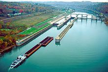
Maxwell Lock and Dam is a navigational lock and gated dam on the Monongahela River between Centerville in Washington County, and Luzerne Township in Fayette County in Pennsylvania. It is part of a series of dams that canalizes the Monongahela to a depth of at least 9 feet (2.7 m) for its entire length from Fairmont, West Virginia to Pittsburgh, Pennsylvania. It is maintained by the U.S. Army Corps of Engineers, Pittsburgh District.
Contents
Map of Maxwell Lock and Dam, Brownsville, PA 15417, USA
Maxwell has two lock chambers located on the right-descending river bank. The dam's upper pool extends about 20.8 miles (33.5 km) upstream to Grays Landing Lock and Dam at Grays Landing, Pennsylvania.
History
Construction on Maxwell Lock and Dam began in 1960 and was completed in 1965. It replaced old Lock and Dam 6 at Rices Landing, Pennsylvania.