
County Fleming County CERCLIS ID KYD980729107 Phone +1 606-783-8680 Proposed 15 October 1984 | State Kentucky Town Hillsboro, Kentucky Listed 10 June 1986 | |
 | ||
Contaminants Heavy metals, radioactive compounds, VOCs, pesticides, and PAHs Responsible
parties 50 "de maximis" parties
306 "de minimis" parties Address 2597 Maxey Flats Rd, Hillsboro, KY 41049, USA Similar Social Service Departme, Veolia Environm Services, Twin Knobs Campgro, Human Resources Departme, St Claire Regional Medical | ||
2011 gsx r 750 rt 1895 maxey flats rd 12 1 12
The Maxey Flat Low-Level Radioactive Waste (LLRW) facility is a Superfund site in Kentucky.
Contents
- 2011 gsx r 750 rt 1895 maxey flats rd 12 1 12
- Location
- Maxey Flat Low Level Radioactive Waste facility
- References
Location
Maxey Flat is a hilltop community in Kentucky approximately 10 miles (16 km) northwest of Morehead and approximately 17 miles (27 km) south of Flemingsburg on Kentucky 1895. It is on the county line of Rowan and Fleming counties. Maxey Flat is in the Knobs physiographic region of Kentucky, an area characterized by flat-topped ridges (Flats) and hills (Knobs). Maxey Flat is one of the largest flat-topped ridges in the area. Though the area is frequently referred to in government documentation as 'Maxey Flats', the historically correct name of the area is simply 'Maxey Flat'.
Maxey Flat Low Level Radioactive Waste facility
As part of a program to encourage the nuclear industry in Kentucky, the Kentucky General Assembly created the Division of Nuclear Information. In 1960 the Kentucky General Assembly passed legislation granting the governor power to enter into agreement with the federal government for the transfer of regulatory powers concerning atomic energy in Kentucky. Also in 1960, Governor Bert T. Combs charged the Cabinet of Health with the regulatory and licensing responsibilities for the handling of radioactive materials. In 1962 Kentucky became the first of the old Atomic Energy Commission "Agreement States." The Kentucky Division of Nuclear Information was then succeeded by the Division of Atomic Development which then transferred its responsibilities to the Kentucky Atomic Energy Authority which eventually became the Kentucky Science and Technology Commission. In retrospect it seems that many of these agencies were established with the hope of bringing a nuclear power plant to Kentucky. Despite being the first state to enter into agreement with the Atomic Energy Commission, Kentucky has never been the site of a nuclear reactor. However, in 1962 Nuclear Engineering Company, Inc. (NECO) bought 252 acres (1.02 km2) of land on Maxey Flat and submitted an application for a license to bury radioactive waste there. The license was granted in January 1963.
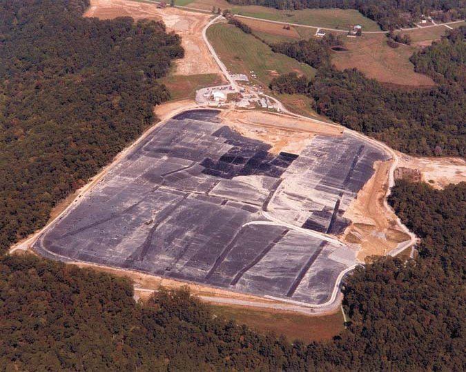
From 1963 to 1977 the Maxey Flat Low Level Radioactive Waste facility served as a dump for 832 corporations and government agencies. The site covered 252 acres (1.02 km2) and consisted of a series of 52 unlined trenches that are an average of 360 feet (110 m) long, 70 feet (21 m) wide and 20 feet (6.1 m) deep. Approximately 4,750,000 cubic feet (135,000 m3) of Low Level Radioactive Waste was deposited on-site. These trenches were capped with dirt when they reached their capacity. Because of the heavy rainfall, soil collapsed into the trenches and they filled with water. It has since been referred to as the "bathtub effect." The water became radioactive and had to be disposed of. Under the direction of President and Chief Executive Officer James N. Neel, Nuclear Engineering Company (referred to in operational documentation as 'NECO'), now known as 'American Ecology' (Nasdaq: ECOL), installed an evaporator and disposed of the accumulated radioactive water as steam from 1973 to April 1986, nearly 9 years after the site had stopped accepting waste materials. The evaporator generally operated 24 hours a day. Approximately six million gallons of liquid were processed by the evaporator. In addition to the trenches for Low Level Radioactive Waste there were "Hot Wells" that were used to store Special nuclear material (plutonium and enriched uranium). The Hot Wells were typically 10 to 15 feet (4.6 m) deep, constructed of concrete, coated steel pipe or tile, and capped with a slab of concrete. Approximately 950 pounds of Special Nuclear Material is buried at Maxey Flat.
On September 27, 1982, the Kentucky New Era reported that the Maxey Flat disposal site was being closed due to "radioactive leakage". Although no immediate health hazard was reported, "the potential [was] still there". State Natural Resources Coordinator Jackie Swigart confirmed that radioactive material had escaped burial trenches and been detected beyond the borders of the 250 acre site. The geology of the Maxey Flat area may contribute to the inadvertent spread of radioactive materials beyond the site's boundaries underground.
From 1987 to 1991 a study was done to determine the best method of cleaning up the site. Extensive remediation was then undertaken, including the installation of a 45 mil scrim-reinforced geomembrane liner covering the site of the trenches to prevent the infiltration of water. The site is currently managed by the Environmental and Public Protection Cabinet of the Commonwealth of Kentucky. The site is considered non-reclaimable and will have to be monitored and maintained in perpetuity. In 2003 the site's nature as a risk to national security came under review by the Department of Homeland Security, primarily because of the transuranic isotopes stored at the site.
In response to concerns that the radioactive isotopes at the site might be used against American interests, DHS had the sign at the entrance to the facility removed so it would be harder to find.