
Elevation 73 m | ||
 | ||
Location North Island, New Zealand Volcanic arc/belt Auckland volcanic field Similar Matukutururu, Mangere Mountain, Ash Hill - New Zealand, Maungarei, Mount Hobson | ||
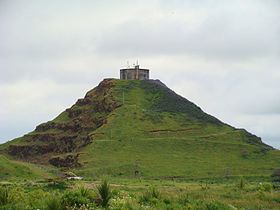
Matukutūreia (also McLaughlins Mountain) is one of the volcanic cones in the Auckland Volcanic Field. It has a peak 73 metres above sea level, and was the site of a pā. The scoria cone was originally crescent-shaped and featured Māori terraces and kumara pits, before extensive quarrying reduced it to a pyramid-shaped mound big enough to support the summit water tank for Papatoetoe. A small part of the summit and the eastern side of the cone were left unquarried, plus a large area of lava flows to the south of the cone remains intact. These remaining parts have recently been transferred to Department of Conservation Management, primarily because of the high heritage values of the Matukuturua Stonefields gardens.
Matukutūreia and nearby Wiri Mountain are collectively known as Matukurua (also Ngā Matukurua).
From July to September 2010, the water tank was removed from the top of Matukutūreia, as part of an agreement when the land was handed over to the Department of Conservation.