
 | ||
Nearest city JérémieLes CayesPort-Salut Nearest cities Jérémie, Les Cayes, Port-Salut | ||
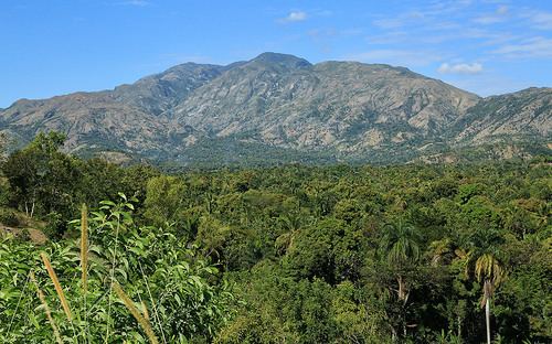
The Massif de la Hotte is a mountain range in southwestern Haiti, on the far-western end of the Tiburon Peninsula. The region is relatively remote and is one of the most biologically diverse and significant areas of all of Hispaniola. It also supports some of the last stands of Haiti's dense cloud forest on its peaks. About 2.5 million years ago, the Massif de la Hotte was separated from the rest of the country by a deep, wide sea channel, which resulted in a hotbed of endemism in its bird, plant, and reptile communities.
Contents
Map of Massif de la Hotte, Haiti
Haiti has a World Heritage site located here. In the wake of the 2010 Haiti earthquake, UNESCO's World Heritage Program is helping Haiti assess the damage.
Biodiversity and conservation
Most of the island's endemic species exist within the 'de la Hotte Biosphere. Rising to a peak level of approximately 7700 ft (2347 m) in Pic Macaya; Haiti's second highest peak, the Massif's high and fluctuating elevations supports some of Hispaniola’s highest levels of biological diversity and endemism. Much of the region lies within the Pic Macaya National Park.
Conservation International recognizes the region as one of the most conservation-urgent in the world in which 13 of Hispaniola's most critically endangered species (all amphibians) occur. Among the most critically endangered frog species are Eleutherodactylus chlorophenax and Eleutherodactylus parapelates, two frog species endemic to Haiti. The Hispaniolan trogon has a recognized presence in the region.