
Existed: ca. 1950 – present | Length 100.4 km | |
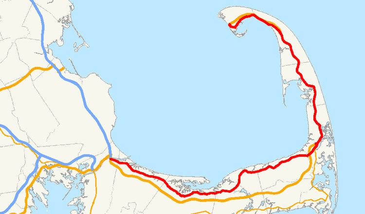 | ||
Massachusetts Route 6A is the state road for two sections formerly known as U.S. Route 6 (US 6) on Cape Cod. Most of Route 6A is also known as the Old King's Highway. Combining the 2 major sections (and a "silent" concurrency with US 6 through Eastham, Wellfleet, and South Truro), the highway is approximately 62 miles (100 km) long.
Contents
Map of MA-6A, Massachusetts, USA
Route description
Although some maps have Route 6A starting at the Bourne Bridge Rotary along Sandwich Road, it actually starts some feet east of the Sagamore Bridge, according to state signage. From there, it goes thus:
Since 1982, Route 6A has ended at an intersection (signalized until 2010) with US 6 at Herring Cove, part of the Cape Cod National Seashore. Before 1982, the intersection was a large complicated rotary-like design, and Route 6A traveled slightly farther north than its intersection with US 6, ending at the exit off the rotary for the remainder of Provincelands Road toward Race Point.
It is signed east/west on both sections of the highway. Until 2015, the highway was signed north/south from Truro and Provincetown.
Some maps erroneously had the northern Route 6A having its southern terminus at US 6 along Mayflower Avenue in Provincetown. However, since Mayflower Avenue is an extremely narrow private road of questionable maintenance, and there is no access from east US 6 to Mayflower Avenue, the reason for this misunderstanding was unknown. This has since been fixed in most maps which once contained this error.
Some maps also erroneously mark US 6's old routing through downtown Wellfleet as Route 6A, though MassHighway (and the Massachusetts Department of Public Works before it) has never included the stretch as part of Route 6A.
History
Route 6A was first signed upon partial completion of the Mid-Cape Highway, which was Cape Cod's first freeway in 1953, traveling between the Sagamore Bridge in Bourne and Route 132 in Barnstable. A second stretch in 1954 was signed when a US 6 bypass was constructed in Truro and Provincetown, although in Provincetown, Route 6A was signed along Bradford Street instead of US 6's former routing on Commercial Street, as the latter road had become one-way westbound. A third stretch in 1956 was signed between Route 132 in Barnstable and the Orleans–Eastham town line when the US 6 freeway was completed.
Route 6A does not officially exist in Eastham or Wellfleet as the road is in an unsigned concurrency with US 6.
The road is generally considered to be Cape Cod's most historic and scenic highway. The Barnstable portion has been listed on the National Register of Historic Places as the Old King's Highway Historic District.
The only portions of the Provincetown section under state (or federal) maintenance are the Commercial Street section (including Bradford between Commercial and Allerton) and the Provincelands Road section (which runs through National Park land). The remainder of the Bradford Street section has always been locally maintained, and though that section carries the occasional mile marker from the last postings in 1979, it has always only sparsely been signed as Route 6A.
There was once another section of Route 6A running through downtown Truro along Truro Center Road, although it was never signed or mile-markered. When Truro Center Road and North Truro's Shore Road were turned back to local maintenance in 1979, the Route 6A designation was officially removed from the downtown Truro section, though locals still referred to it as "Route 6A" until it was officially named "Truro Center Road."
The section of Route 6A from North Truro to its terminus in the Cape Cod National Seashore was signed as a north–south route until 2015 when MassDOT completed replacement of those signs with east–west signage.
Major intersections
The entire route is in Barnstable County.