
Existed: 1963 – present Length 2.53 km | Counties: Carroll Constructed 1963 | |
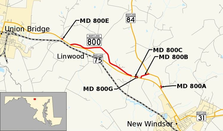 | ||
Maryland Route 800 (MD 800) is a collection of state highways in the U.S. state of Maryland. The longest section of MD 800, officially MD 800D and known as Watson Lane, is signed and runs 1.57 miles (2.53 km) between two intersections with MD 75 near the unincorporated village of Linwood in western Carroll County. The multiple segments of MD 800 are sections of old alignment of MD 75 between Union Bridge and New Windsor. MD 75 was originally constructed through Linwood in the early 1920s. MD 800 sections were assigned after MD 75 was relocated through the area in the early 1960s.
Contents
Route description
MD 800D begins at a perpendicular intersection with MD 75 (Green Valley Road) a short distance west of Linwood. The state highway heads north then turns east at a spur of old alignment that serves a farm. MD 800D crosses Wolf Pit Branch and closely parallels MD 75 until after the intersection with McKinstry Mill Road, which passes through the Linwood Historic District south of its intersection with MD 75. The state highway continues east, with farmland to the north and woods separating the highway from MD 75 until MD 800D reaches its eastern terminus at MD 75 opposite Winters Church Road.
History
MD 800 consists of segments of MD 75 that were originally constructed as concrete roads between 1921 and 1923. The sections of roadway received their modern designations after MD 75 was relocated between Union Bridge and New Windsor around 1963. East of MD 800B, MD 84 was extended south to its present terminus over the old alignment of MD 75.
Junction list
The entire route is in Linwood, Carroll County.
Auxiliary routes
There are five other existing sections of MD 800, all of which are unsigned. MD 800G is a connector between MD 75 and MD 800C; the other four highways and the extinct MD 800F are sections of old alignment of MD 75.