
Existed: 1974 – present Length 1.75 km | Constructed 1974 | |
 | ||
North end: MD 756 near Pocomoke City | ||
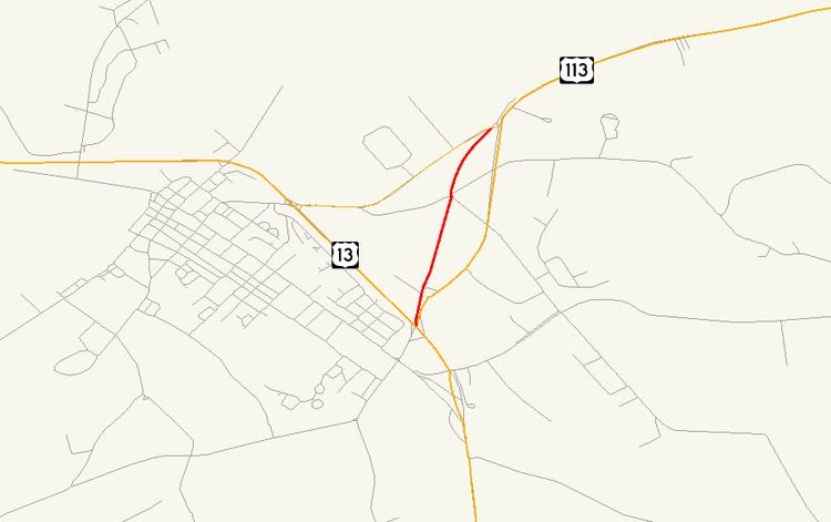
Maryland Route 359 (MD 359) is a state highway in the U.S. state of Maryland. Known as Bypass Road, the state highway runs 1.09 miles (1.75 km) from a dead end adjacent to the junction of U.S. Route 13 and US 113 north to MD 756 within Pocomoke City. What is now MD 359 and unsigned MD 250A was part of a bypass of the center of Pocomoke City for the southernmost part of US 113 that was constructed in the mid-1930s. US 113 originally followed MD 756 to its southern terminus at what is now US 13 Business. The bypass was itself bypassed in the 1970s when US 113 was expanded to a four-lane divided highway to end at US 13.
Contents
- Map of MD 359 Pocomoke City MD 21851 USA
- Route description
- History
- Junction list
- Auxiliary routes
- References
Map of MD-359, Pocomoke City, MD 21851, USA
Route description
MD 359 begins at a dead end adjacent to Worcester Post 93 of the American Legion. The state highway heads north as a two-lane road and meets American Legion Drive (unsigned MD 359B), which provides access to US 113 near its southern terminus at US 13. MD 359 continues north through a mix of residences and farms, meeting Carter Road, Byrd Road, and Groton Road at a five-way intersection. The state highway reaches its northern terminus at an oblique intersection with MD 756 (Old Snow Hill Road), a short distance west of MD 756's end at US 113.
History
US 113 presently follows its third alignment in Pocomoke City. The first alignment, to which US 113 was assigned in 1927, began at US 13 (now US 13 Business) within the city limits, following Sixth Street and Linden Avenue to the western end of what is now MD 756. US 113 then followed MD 756 to its present intersection with US 113. The second alignment is followed by present-day MD 250A and MD 359 between US 13 (now US 13 Business) and MD 756, and MD 359A north of MD 756. This bypass was completed in 1936. The present US 113 four-lane divided highway was constructed in 1974, cutting off the second alignment's direct access to US 13, which had moved to its own four-lane divided bypass of Pocomoke City in 1963.
Junction list
The entire route is in Pocomoke City, Worcester County.
Auxiliary routes
MD 359 has two auxiliary routes. Both MD 359A and MD 359B were assigned at the same time as MD 359 shortly after the completion of the present alignment of US 113 in the 1970s.