
Existed: 1927 – present Length 29.8 km | Constructed 1927 | |
 | ||
Counties | ||
Maryland Route 309 (MD 309) is a state highway in the U.S. state of Maryland. The state highway runs 18.50 miles (29.77 km) from U.S. Route 50 (US 50) in Easton north to MD 213 south of Centreville. MD 309 is a C-shaped highway that passes through northeastern Talbot County and southeastern Queen Anne's County, connecting Easton and Centreville with Queen Anne, where the highway intersects MD 404. MD 309 was originally designated along the highway between Easton and Queen Anne. The highway was constructed south from Queen Anne to Cordova in the late 1920s along MD 303's current course and from Cordova to Easton in the early 1930s. In 1955, MD 309 gained its northern segment by assuming MD 303, which originally followed the Queen Anne–Centreville portion of the present MD 309. When MD 309 moved to a new alignment between Cordova and Queen Anne in the early 1960s, MD 303 was assigned to the old alignment.
Contents
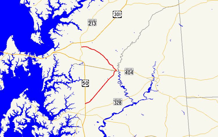
Map of MD-309, Maryland, USA
Route description
MD 309 begins at an intersection with US 50 (Ocean Gateway) opposite Airport Road to the east of Easton Airport in Easton. The state highway heads east as two-lane Black Dog Alley for a short distance before turning northeast onto Cordova Road and leaving the town of Easton. MD 309 heads north through a mix of farmland and forest parallel to the abandoned railroad grade of the Easton–Clayton branch of the Maryland and Delaware Railroad. After passing through the village of Cordova, the state highway intersects MD 303 (Tappers Corner Road). MD 309 veers away from the railroad grade, crosses Norwich Creek, and intersects MD 404 Alternate west of Queen Anne before entering Queen Anne's County at the intersection with Park Avenue and Flowers Road. At the intersection with MD 303 (Main Street), MD 309 turns northwest onto Starr Road and intersects MD 404 (Queen Annes Highway). North of Queen Anne, the state highway traverses farmland, meets the southern end of MD 481 (Damsontown Road), and passes through the hamlet of Starr before reaching its northern terminus at MD 213 (Centreville Road) south of Centreville.
History
MD 309 originally consisted of the highway between Easton and Queen Anne. The highway from Queen Anne to south of Centreville was originally MD 303. A small piece of MD 309 was paved south of Queen Anne by 1921. Construction of the remainder of the highway to Cordova began in 1925 and was completed in 1929. The Cordova–Easton section was completed by 1933. In 1955, MD 309 assumed the length of MD 303 north to near Centreville. A present alignment of MD 309 opened between Cordova and Queen Anne in 1960; the old highway became the second edition of MD 303 in 1961. The southernmost portion of MD 309 was moved from Cordova Road to Black Dog Alley in 1995.