
Existed: 1927 – present Length 32.78 km | Constructed 1927 | |
 | ||
Touristroutes: Chesapeake Country Scenic Byway County | ||
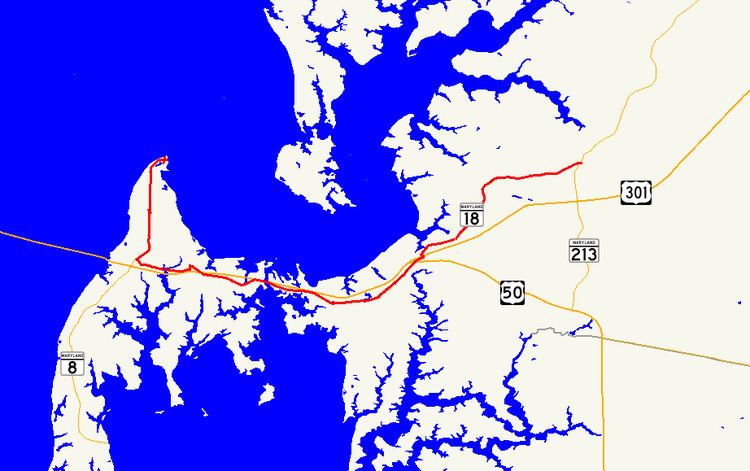
Maryland Route 18 (MD 18) is a state highway in the U.S. state of Maryland. The state highway runs 20.37 miles (32.78 km) from the beginning of state maintenance at Love Point east to MD 213 in Centreville. MD 18 is the main east–west local highway on Kent Island and east to Centreville, serving the centers of Stevensville, Chester, Kent Narrows, Grasonville, and Queenstown that are bypassed by U.S. Route 50 and US 301. What is signed as MD 18 is actually a set of four suffixed highways: MD 18A, MD 18B, MD 18S, and MD 18C. There are also several unsigned segments of MD 18 scattered along the length of the signed portions.
Contents
Map of MD-18, Maryland, USA
What is now MD 18 was first paved in the 1910s from Centreville to Queenstown along with short segments in Grasonville and Chester. Gaps in the Stevensville–Queenstown highway were filled throughout the 1920s, leaving only a crossing of Kent Narrows to be completed in the early 1930s. MD 18 between Stevensville and Love Point was constructed in the early 1930s. The Stevensville–Queenstown highway was designated part of MD 404, while the highways on both ends to Love Point and Centreville were designated MD 18. US 50 replaced MD 404 when the former highway was extended east of Annapolis in 1949. When US 50 was relocated as a divided highway between the Chesapeake Bay Bridge and Queenstown in the early 1950s, MD 18 was assigned to the bypassed highway. Since the mid-1980s, several suffixed sections of MD 18 have been created, relocated, or received new designations due to expansion of US 50 and US 301 to a freeway.
Route description
The mainline of MD 18 consists of four internally suffixed sections. MD 18A runs 5.39 miles (8.67 km) from Love Point south and east through Stevensville to a roundabout at Castle Marina Road in Chester. MD 18B extends 7.94 miles (12.78 km) from the same roundabout east through Chester, Kent Narrows, and Grasonville to US 50 in Queenstown. MD 18S has a length of 0.33 miles (0.53 km) between US 50 and US 301 in Queenstown. MD 18C comprises the easternmost 6.71 miles (10.80 km) of the highway from US 301 in Queenstown to MD 213 in Centreville.
MD 18A's western terminus is at the beginning of state maintenance on Love Point Road just south of the community of Love Point at the northern end of Kent Island. The state highway heads due south through farmland. After meeting Old Love Point Road at an acute angle, MD 18A passes suburban subdivisions and Kent Island High School. Love Point Road, which is unsigned MD 835C, veers southeast to pass through the Stevensville Historic District, which contains the historic Cray House, the Stevensville Bank building, and Christ Church. MD 18A curves to the southwest as Business Parkway. The state highway expands to a four-lane divided highway ahead of the intersection with MD 8. MD 8 continues south on the divided highway toward an interchange with US 50 and US 301 (Blue Star Memorial Highway) just east of the Chesapeake Bay Bridge while MD 18A turns east onto Main Street. MD 18A curves around the southern edge of the Stevensville Historic District, intersecting Love Point Road, which is unsigned MD 759B to the south, and the other end of MD 835C (East Main Street). The state highway passes Stevensville Middle School, crosses Cox Creek, and passes the Kent Island Shopping Center before reaching its eastern terminus at a roundabout with Castle Marina Road, which is unsigned MD 18H to the south.
MD 18B begins at the same roundabout at which MD 18A has its eastern terminus. Piney Creek Road, which is unsigned MD 18T, splits to the east as MD 18B curves southeast and crosses over US 50 and US 301. The state highway curves east again at an intersection with its old alignment, Postal Road, in Chester shortly before an intersection with MD 552 (Dominion Road). MD 18B continues around the south end of Piney Creek before entering the hamlet of Kent Narrows, where the highway has a direct connection to eastbound US 50 and US 301. The state highway also has an indirect connection to the westbound freeway via Piney Narrows Road immediately before crossing Kent Narrows on a drawbridge adjacent to the US 50 and US 301 crossing of the strait. MD 18B continues east through Grasonville, where the highway intersects Chester River Beach Road (unsigned MD 18V) and Nesbit Road (unsigned MD 835K), both of which provide full access to the freeway. The state highway continues through farmland before reaching its eastern terminus at US 50 (Ocean Gateway) just east of the US 50 – US 301 split in Queenstown. The two highways meet at a superstreet intersection, so there is no direct access between MD 18B and MD 18S on the opposite side of the intersection.
MD 18S begins at US 50 opposite MD 18B's eastern terminus. At the intersection with MD 656 (Friels Road) and Outlet Center Drive, which heads into the Queenstown Premium Outlets, the state highway turns north and reaches its eastern terminus at a superstreet intersection with US 301 (Blue Star Memorial Highway). MD 18C begins at US 301 opposite the eastern terminus of MD 18S. The state highway heads northeast as Main Street through the town of Queenstown, where the highway intersects MD 456 (Del Rhodes Avenue) and passes near the historic home Bowlingly. After leaving the town, MD 18C's name changes to 4-H Park Road and the road passes through farmland. The state highway passes the namesake park of the youth agricultural organization shortly after crossing Reed Creek. MD 18C passes by the historic home Bachelor's Hope before the highway reaches its eastern terminus at MD 213 (Centreville Road) on the southwestern edge of Centreville.
History
The first sections of MD 18 was paved as three separate state-aid roads within Queenstown and Grasonville by 1915, and between Stevensville and Chester shortly after 1915. The first section paved as a state road was between Centreville and Queenstown by 1919; there were also short pieces of state road paved in Chester and east of Grasonville by 1921. The state road in Chester was extended east to Kent Narrows and the state road near Grasonville was extended west through the village in 1923. The Stevensville–Chester road and the Queenstown–Centreville road were marked as MD 18 by 1927. The road from Stevensville to Love Point was started in 1929 and completed to just south of Love Point in 1930. The highway was extended to its present western terminus by 1933. Pavement was also laid from the west end of Grasonville to Kent Narrows by 1930. The east–west highway between Stevensville and Queenstown was finished with the completion of a timber trestle bascule bridge over Kent Narrows. That highway was marked as MD 404 in 1933; the highways from Stevensville to Love Point and from Queenstown to Centreville remained marked as MD 18.
When US 50 was extended to the Eastern Shore in 1949, it was routed along MD 404 to Wye Mills. The US 50 divided highway started construction in 1950 and was completed between the Chesapeake Bay Bridge and Queenstown in 1952, including a new drawbridge over Kent Narrows. The 1933 bridge over Kent Narrows was dismantled in 1953. MD 18 was subsequently assigned to old US 50 between Stevensville and Queenstown, following its own alignment except for a concurrency with US 50 and later US 301 over Kent Narrows.
Business Parkway was constructed in 1987 as a new alignment and northern extension of MD 8. MD 18 was extended west to Business Parkway and north on the divided highway to bypass the Stevensville Historic District in 1989; the old alignment was designated MD 835C. MD 18 also bypassed the center of Chester in 1989 by the construction of an overpass of US 50 and US 301 just west of MD 552, replacing the intersection at Castle Marina Road. The latter improvement was part of the transformation of US 50 and US 301 to a freeway from the Chesapeake Bay Bridge to Queenstown, which was completed in 1991. The upgrade included a new fixed high-level bridge over Kent Narrows for US 50 and US 301, relegating the 1952 drawbridge to be used only by MD 18. In 1999, MD 18 was relocated to the north to use a new roundabout at Castle Marina Road in Chester; the old mainline was designated MD 18R. The MD 18 – US 301 junction in Queenstown was transformed into a superstreet intersection in 2003, resulting in the splitting of the MD 18C designation; MD 18S was assigned to the highway south of the junction.
As part of the reconstruction of US 50 as a six-lane freeway from US 301 in Queenstown to MD 404 in Wye Mills, the Maryland State Highway Administration plans to construct an overpass of MD 18 over US 50 in Queenstown. MD 18 and US 50 would become connected by a pair of right-in/right-out interchanges. Access to eastbound US 50 would be via a new service road south of US 50 and connections with westbound US 50 would be made through Outlet Center Drive. As of 2011, the project has not been funded.
Junction list
The entire route is in Queen Anne's County.
Auxiliary routes
MD 18 has 12 unsigned auxiliary routes. MD 18F, MD 18I, and MD 18U through MD 18Z are in Grasonville. MD 18G is in Queenstown. MD 18H, MD 18R, and MD 18T are in Chester.