
Existed: 1927 – present Counties: Harford Constructed 1927 | Length 27.91 km | |
 | ||
South end: | ||
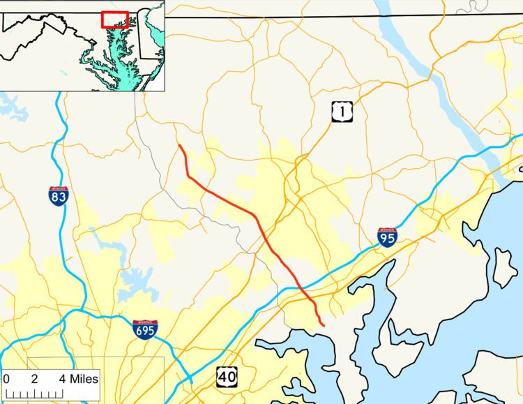
Maryland Route 152 (MD 152) is a state highway in the US state of Maryland. The state highway runs 17.34 miles (27.91 km) from an entrance to Aberdeen Proving Ground in Edgewood north to MD 146 near Taylor. MD 152 parallels the western edge of Harford County, connecting the communities of Joppatowne and Fallston with Interstate 95 (I-95), U.S. Route 40, and US 1. The state highway north of Joppa was mostly built in the late 1920s and early 1930s. MD 152 south of Joppa was built around 1940; shortly thereafter, the highway was reconstructed as a wartime access project. The state highway originally did not have an interchange with I-95; a partial interchange was built in the early 1970s and completed in the mid 1990s concurrent with the expansion of the highway to a four-lane divided highway through Joppa.
Contents
Map of MD-152, Fallston, MD 21047, USA
Route description
MD 152 begins at an entrance to the Edgewood Area of Aberdeen Proving Ground. The state highway heads north as two-lane Magnolia Road and crosses over the Amtrak Northeast Corridor and MARC's Penn Line. MD 152 passes through the community of Magnolia, where the highway intersects Trimble Road, which connects the community with Edgewood to the east and Joppatowne to the west. The state highway expands to a four-lane divided highway ahead of its intersection with US 40 (Pulaski Highway), where the highway's name changes to Mountain Road. MD 152 crosses over CSX's Philadelphia Subdivision to arrive in the community of Joppa, where the highway is paralleled to the west by its old alignment, Old Mountain Road South. The state highway intersects MD 7 (Philadelphia Road) before meeting I-95 (John F. Kennedy Memorial Highway) at a diamond interchange. The interchange ramps to and from Baltimore intersect the old alignment.
North of I-95, MD 152 receives the northern end of Old Mountain Road South and reduces to two lanes to pass through the hamlet of Clayton. The state highway, which is paralleled on the east by another loop of old alignment, Old Mountain Road Central, has many sections of three lane road with center turn lane on its way northwest to Fallston. The state highway intersects Singer Road and Jerusalem Road in the village of Mountain. Singer Road heads east past the historic school McComas Institute; Jerusalem Road heads west to Jerusalem, a village within Gunpowder Falls State Park on Little Gunpowder Falls that contains the Jerusalem Mill Village and the Jericho Farm, which are connected by the Jericho Covered Bridge. Through the hamlet of Stockton, MD 152 is paralleled to the west by Old Mountain Road North and intersects Old Joppa Road, which heads northeast toward Bel Air providing access to the historic farm Olney and the Norris-Stirling House.
MD 152 enters the community of Pleasant Hills, where it expands to a four-lane divided highway and intersects US 1 (Belair Road) and MD 147 (Harford Road) in commercial areas in the hamlets of Lynchs Corner and Bagley, respectively. MD 152 continues northwest as two-lane Fallston Road into Fallston. Old Fallston Road splits to the west; the old alignment provides access to the Little Falls Meetinghouse, the historic home Bon Air, and Fallston Airport. MD 152 veers more toward the west at its intersection with the old alignment and Carrs Mill Road, which leads to historic Rockdale. As the state highway passes through the hamlet of Scarff, its surroundings transition from suburban residential development to farmland. MD 152 intersects MD 165 (Baldwin Mill Road) in the community of Upper Crossroads, then veers north at its junction with Hess Road in the hamlet of Rutledge. The state highway reaches its northern terminus at MD 146 (Jarrettsville Pike) near Taylor.
MD 152 is a part of the National Highway System as a principal arterial from US 40 to I-95 in Joppatowne and from Singer Road south of Pleasant Hills to Pleasantville Road near Fallston.
History
The first section of MD 152 was constructed as a macadam road from the Maryland and Pennsylvania Railroad crossing just north of Watervale Road in Fallston to Pleasantville Road in Scarff by 1910. The paved highway was extended north to Rutledge in 1928. The segment from Fallston to MD 147 at Bagley, which was a county highway in 1930, was resurfaced in macadam in 1932. MD 152 was paved in macadam from US 40 (now MD 7) in Joppa north to Bagley in 1932 and 1933. The state highway was extended north from Rutledge to MD 146 near Taylor in 1938.
A disjoint segment of MD 152 was constructed from US 40 south to Magnolia in 1940. At its southern end, instead of continuing southeast across the Pennsylvania Railroad (now Amtrak), the state highway curved to the southwest along what is now Fort Hoyle Road to end where Fort Hoyle Road turns north. Only two years later, the southern segment of MD 152 was widened and resurfaced as a military access project. A bridge over the railroad was constructed as part of a new alignment built starting in 1942 to provide better access to the Edgewood Arsenal; the project was completed by 1944. The gap in MD 152 was filled in 1951 when the highway between US 40 and MD 7 was brought into the state highway system.
MD 152 was widened, resurfaced, and relocated, leaving behind several sections of old alignment, for most of its length in the late 1950s. The highway was reconstructed between Rutledge and Fallston starting in 1957 and from Fallston to Stockton beginning in 1958. MD 152 was expanded to a four-lane divided highway from south of US 1 to north of MD 147 in 1964. When I-95 was constructed northeast of Baltimore in 1963, no interchange was constructed with MD 152. The I-95–MD 152 interchange was constructed as a partial interchange with ramps to and from Baltimore in 1973. The interchange was expanded with ramps from southbound I-95 to MD 152 and from MD 152 to northbound I-95 in 1994. MD 152 was also expanded to a divided highway from south of MD 7 to north of the I-95 interchange and around the US 40 intersection in 1994. The gap in divided highway between US 40 and MD 7 was filled when the highway's bridge over CSX's Philadelphia Subdivision was reconstructed in 1996.
Junction list
The entire route is in Harford County.