
Existed: 1952 – present Constructed 1952 | Length 96.98 km | |
 | ||
Tourist
routes: Historic National Road
Chesapeake and Ohio Canal Scenic Byway
Antietam Campaign Scenic Byway Counties Allegany County, Maryland | ||
Maryland Route 144 (MD 144) is a collection of state highways in the U.S. state of Maryland. These highways are sections of old alignment of U.S. Route 40 (US 40) between Cumberland and Baltimore. Along with US 40 Scenic, US 40 Alternate, and a few sections of county-maintained highway, MD 144 is assigned to what was once the main highway between the two cities, connecting those endpoints with Hancock, Hagerstown, Frederick, New Market, Mount Airy, Ellicott City, and Catonsville. MD 144 has seven disjoint sections of mainline highway that pass through mountainous areas of Allegany and Washington counties and the rolling piedmont of Frederick, Carroll, Howard, and Baltimore counties.
Contents
- Map of MD 144 Maryland USA
- Route description
- CumberlandFlintstone
- Hancock
- Hagerstown
- FrederickBartonsville
- New Market
- Mount Airy Ellicott City
- Ellicott City Baltimore
- History
- MD 144WB
- MD 144 Allegany
- MD 144WA
- MD 144FA
- MD 144FB
- Auxiliary routes
- References
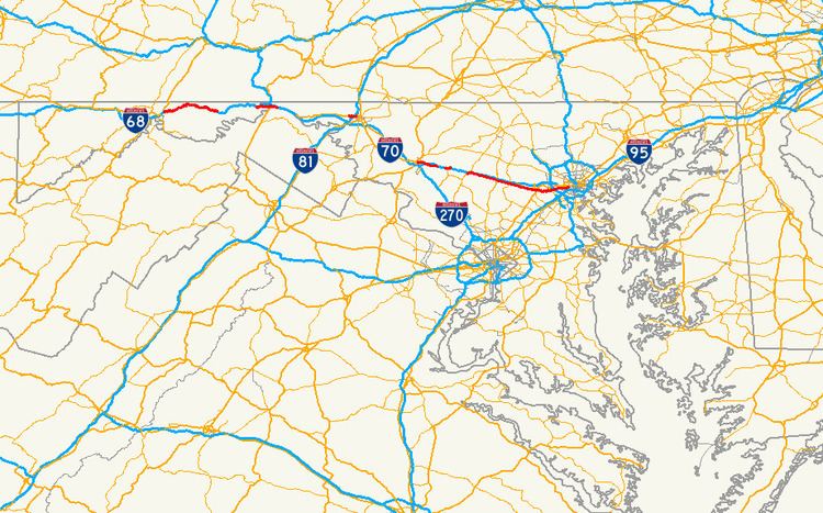
Map of MD-144, Maryland, USA
Route description
There are seven mainline sections of MD 144:
MD 144 is a part of the National Highway System as a principal arterial in two sections. The first section runs from the western terminus of MD 144FA at Jefferson Street east to I-70 and US 40 within Frederick. The second section runs from North Rolling Road in Catonsville to the highway's eastern terminus at US 1 in Baltimore.
Cumberland–Flintstone
MD 144 begins at an intersection with MD 807 (Bedford Road) a short distance north of the Cumberland city limits. The state highway heads east as two-lane Naves Cross Road, passing through a pair of ridges before meeting a pair of ramps to and from westbound I-68 (National Freeway). Naves Cross Road continues east as MD 807A, while MD 144 turns south onto Christie Road to pass under I-68. Christie Road continues south while MD 144 turns east onto Ali Ghan Road. The state highway crosses Evitts Creek before receiving an exit ramp from eastbound I-68 and joins US 220 in a short concurrency. US 220 turns north onto its bypass of Bedford Road while MD 144 continues east, meeting I-68 at Exit 47, a diamond interchange.
Within the interchange, MD 144 becomes National Pike and expands to a four-lane divided highway that follows the valley of Elk Lick Run. The state highway passes under I-68 and reduces to a two-lane highway at Hinkle Road. At Rocky Gap Road, MD 144 begins to closely parallel the eastbound lanes of I-68. The state highway leaves the valley of Elk Lick Run and ascends Martin Mountain. On the climb, MD 144 intersects Pleasant Valley Road, which meets I-68 at Exit 50 and leads to Rocky Gap State Park. At the top of Martin Mountain, the state highway crosses over I-68 and intersects Sunset Orchard Road, which leads to a ramp to westbound I-68. On the descent, MD 144 crosses I-68 again and receives a ramp from the eastbound direction of the freeway and the highways part ways around a quarry.
MD 144 curves around the quarry and rejoins the side of I-68 as the highway passes West Wilson Road and crosses a tributary of Flintstone Creek. The state highway leaves the freeway and passes through the unincorporated village of Flintstone, where the state highway intersects the Exit 56 ramps to and from eastbound I-68 and Black Valley Road, which leads to ramps for westbound I-68. MD 144 joins I-68 and Flintstone Creek in passing through a gap in Warrior Mountain. Gilpin Road, an older alignment of US 40 that is designated MD 144AE, begins to parallel the eastbound side of the state highway at Town Creek Road. The two surface highways cross Town Creek and begin to climb Polish Mountain, with MD 144 following a gentle curve while Gilpin Road follows a winding alignment. MD 144 intersects Gilpin Road as the highway begins the descent from the mountain. MD 144 and I-68 follow Pratt Hollow east between several ridges. The state highway crosses the freeway and over Pine Lick Hollow and closely parallels the westbound direction of I-68 before reaching its eastern terminus at US 40 Scenic (Old National Pike) just north of I-68 Exit 62, just west of Fifteen Mile Creek, and on the edge of Green Ridge State Forest.
Hancock
MD 144 begins at Exit 77 of I-68 (National Freeway) north of Woodmont and west of Hancock. The state highway heads south through the diamond interchange to an intersection with US 40 Scenic (National Pike), at which MD 144 turns east as two-lane Western Pike. The state highway intersects Woodmont Road and crosses Little Tonoloway Creek before ascending Tonoloway Ridge. East of the ridge, MD 144 passes through multiple curves through a mixture of farms and forest, intersecting Locher Road, which leads to Fort Tonoloway State Park, before passing Hancock Middle-Senior High School at the town limits of Hancock. The state highway passes through a residential area before issuing a ramp to southbound US 522. MD 144 passes under US 522 itself, crosses Little Tonoloway Creek, and intersects Limestone Road, which is the old alignment of US 522 and unsigned MD 894.
MD 144 continues east as Main Street through downtown Hancock. Access to northbound US 522 as well as both I-70 and I-68 is provided by Virginia Avenue. MD 144 parallels both the Western Maryland Rail Trail and Chesapeake and Ohio Canal National Historical Park one block to the north through the downtown area. The state highway leaves the town limits and passes the C&O Canal's Hancock visitor center before crossing Tonoloway Creek. MD 144 reaches its eastern terminus at a partial interchange with I-70 (Eisenhower Memorial Highway). There is no direct access from MD 144 to westbound I-70 at Exit 3; that movement can be completed by turning around at Exit 5.
Hagerstown
MD 144 begins at an intersection with US 40 (National Pike) between Huyett and Hagerstown. The state highway heads east as two-lane Washington Street past farmland, residential subdivisions, and a cemetery. After crossing over I-81 (Maryland Veterans Memorial Highway) with no access, MD 144 enters an industrial area and reaches its eastern terminus at a roundabout with Western Maryland Parkway. Western Maryland Parkway, which is unsigned MD 910C heading north, is used to access US 40 and I-81. Washington Street continues east into the city of Hagerstown, where it meets US 40 again in the downtown area.
Frederick–Bartonsville
The old alignment of US 40 through Frederick begins at a partial cloverleaf interchange with the Frederick Freeway, which heads north from the interchange as US 15 and south as a concurrency of US 15 and US 40. Patrick Street heads east from the interchange as a four-lane undivided highway that splits into a one-way pair just beyond Catoctin Street. The eastbound direction, which is signed as eastbound MD 144 at the split, follows municipally-maintained South Street. MD 144 in Frederick officially begins at the intersection of Patrick Street, which is one-way westbound, and Jefferson Street, which was formerly US 340. Both streets pass through the Frederick Historic District: Patrick Street crosses Carroll Creek into the commercial district, while South Street has a more residential flavor. Both streets intersect Market Street, the main north–south thoroughfare of the downtown area that was formerly MD 355. The eastbound direction of MD 144 turns north onto East Street, passing by the Frederick MARC station and traversing Carroll Creek before meeting Patrick Street.
MD 144 heads east from downtown Frederick on two-lane Patrick Street. The state highway crosses Carroll Creek and passes between a residential area to the south and the Frederick Fairgrounds to the north. MD 144 expands to a four-lane undivided street and continues east through an industrial area where the highway intersects Monocacy Boulevard, which is used to access westbound I-70 and Frederick Municipal Airport. Just before reaching I-70, the street's alignment continues straight as an unnamed road, unsigned MD 870G, that receives the westbound Exit 56 ramp from I-70 and is used to access Bowmans Farm Road. MD 144 reduces to two lanes and veers to the southeast to cross I-70 (Baltimore National Pike), then curves back to the original alignment ahead of ramps to and from eastbound I-70 at the intersection with Quinn Orchard Road.
MD 144 continues east as Old National Pike, a two-lane road that is paralleled by an unused carriageway immediately to the north that serves as a park and ride and the original alignment further north, which is lined with scattered residences. The two southern carriageways cross the Monocacy River on bridges while the northernmost road dead ends at the site of the removed Jug Bridge. East of Bartonsville Road, MD 144 expands to a four-lane divided highway, with the westbound direction making use of what to the west was an unused carriageway. The original alignment, Baltimore Road, now parallels the highway to the south, while Long Branch parallels the highway to the north. MD 144 crosses Long Branch before approaching its eastern terminus. Westbound MD 144 receives a loop ramp from Exit 59 of westbound I-70. The old alignment, Old National Pike, heads north from the divided highway, passes under I-70, and turns east toward New Market as a county highway. MD 144 continues east to its terminus at Ijamsville Road, where the divided highway ends, with the eastbound direction becoming an entrance ramp to eastbound I-70.
New Market
Old National Pike parallels I-70 as a county highway for about 3 miles (4.8 km) to the western town limits of New Market. MD 144 begins again at the town limit 0.03 miles (0.048 km) west of Royal Oak Drive. The state highway, known as Main Street, passes through the New Market Historic District, within which it intersects MD 874 (Prospect Street). MD 144 becomes Old National Pike again at the east town limit. The original alignment continues straight to a dead end while the state highway turns north and then east to its eastern terminus at MD 75 (Green Valley Road), which is used to access I-70. Old National Pike continues east as a county highway for about 6 miles (9.7 km) to Mount Airy on the Frederick–Carroll county line.
Mount Airy – Ellicott City
MD 144 begins at an intersection with MD 27 (Ridge Road) just south of MD 27's interchange with I-70 south of Mount Airy. The state highway, known as Frederick Road, immediately turns north and after 0.07 miles (0.11 km) crosses the Frederick–Carroll County line. MD 144 passes Parr's Spring, the source of the Patapsco River, before curving to the east through residential subdivisions and closely paralleling the eastbound lanes of I-70. Shortly after crossing the Patapsco River and entering Howard County, the state highway veers away from the freeway and passes through a mix of farmland and scattered residences. MD 144 intersects Long Corner Road and Watersville Road before reaching Lisbon, where the highway meets MD 94 (Woodbine Road) at a roundabout. The state highway continues past Daisy Road and Morgan Station Road to Cooksville, where the highway passes the historic Roberts Inn and intersects MD 97 (Roxbury Mills Road). MD 144 continues east to West Friendship, where the highway crosses the Middle Patuxent River and Terrapin Branch, passes the Howard County Fairgrounds, and intersects MD 32 (Sykesville Road). The state highway leaves the farmland behind and passes through a mixture of forest and residential subdivisions, passing Marriottsville Road and Folly Quarter Road. On the western edge of Ellicott City, MD 144 reaches its eastern terminus at US 40 (Baltimore National Pike).
Ellicott City – Baltimore
Frederick Road splits off from US 40 as a county highway about 1 mile (1.6 km) east of the eastern end of the Mount Airy – Ellicott City portion of MD 144. This county highway parallels US 40 to the south, crossing the passes through residential subdivisions, crossing the Little Patuxent River, intersecting Centennial Lane and St. John's Lane, and passing the historic home MacAlpine. Frederick Road passes under US 29 (Columbia Pike) before intersecting Toll House Road. The county highway intersects Rogers Avenue and descends into downtown Ellicott City as Main Street. Within the Ellicott City Historic District and nearby are the Howard County offices and the Howard County Circuit Courthouse, the remains of the Patapsco Female Institute, and the Ellicott City Station, which preserves the oldest remaining passenger train station in the U.S. as a railroad museum. The highway passes under the Oliver Viaduct, which carries CSX's Old Main Line Subdivision, before crossing the Patapsco River into Baltimore County.
MD 144 begins at the county line as two-lane Frederick Road, where the state highway passes through the Ellicott's Mills Historic District. The state highway parallels the Patapsco River east to River Road, where the highway gains an eastbound climbing lane and leaves the steep river valley. MD 144 passes several loops of old alignment on the ascent, which concludes shortly after passing Old Frederick Road. MD 144 continues east through a densely populated residential area, intersecting North Rolling Road and entering Catonsville, where the highway intersects MD 166 (South Rolling Road), which heads south toward the University of Maryland Baltimore County and Baltimore/Washington International Thurgood Marshall Airport (via I-195). The state highway passes close to the historic home Summit and passes between the Old Catonsville Historic District and Central Catonsville and Summit Park Historic District as it enters downtown Catonsville, which contains Old Catonsville High School. At the eastern end of the central business district, MD 144 passes Wade Avenue, which heads south to Spring Grove Hospital Center, before meeting I-695 (Baltimore Beltway) at a diamond interchange.
Shortly after the interchange with I-695, MD 144 enters the city of Baltimore, where it continues as Frederick Avenue. The state highway passes Baltimore National Cemetery, Mount Saint Joseph College high school, the Schwartze Mansion, and Loudon Park National Cemetery in an affluent residential area. MD 144 expands to a four-lane undivided highway at Beechfield Avenue before reaching Hilton Street and Caton Avenue, where the highway crosses over the Amtrak Northeast Corridor. The state highway continues east through a less affluent series of neighborhoods where it crosses over Gwynns Falls. East of Bentalou Street, MD 144 splits into a one-way pair, with the eastbound lanes following Pratt Street and the westbound lanes following Frederick Avenue and then Lombard Street. The state highway intersects US 1 at its own one-way pair, Monroe Street southbound and Fulton Avenue northbound. Both directions of MD 144 have their eastern terminus at Fulton Avenue, although Frederick Avenue itself continues two more blocks to its own terminus at Baltimore and Gilmor Streets. Both Pratt Street and Lombard Street continue east toward downtown Baltimore, passing through the Union Square neighborhood and by the Mount Clare Shops and the B&O Railroad Museum.
History
In 2014, the group Preservation Howard County placed the road on its top 10 most endangered list, followed by Preservation Maryland in 2015. In 2015, a roundabout was constructed at the eastern terminus of the Hagerstown section of MD 144 at MD 910C.
MD 144WB
MD 144 follows what was constructed as the Baltimore and Cumberland Turnpike through Hancock in the 19th century. This highway was reconstructed as one of the original state roads by the Maryland State Roads Commission. The highway was paved from Little Tonoloway Creek to the western edge of Hancock in 1913, and from there east through the town to east of Tonoloway Creek in 1915. The highway through Hancock followed the same alignment as modern MD 144 except for a circuitous alignment on both sides of Tonoloway Creek that followed what is now Old Route 40, Tollgate Ridge Road, and Ford Drive. The present bridge and alignment were constructed in 1940. Construction on I-70 from the Pennsylvania state line to east of Tonoloway Creek began in 1963. By 1964, a US 40 bypass of Hancock, following what is now I-68 from Exit 77 to I-70, was under construction. I-70 and the US 40 bypass were completed in 1966. MD 144 was marked along the old alignment of US 40 through Hancock by 1967.
MD 144 Allegany
The entire route is in Allegany County.
MD 144WB
The entire route is in Washington County.
MD 144WA
The entire route is in Washington County.
MD 144FA
The entire route is in Frederick County.
MD 144FB
The entire route is in New Market, Frederick County.
Auxiliary routes
MD 144 has four auxiliary routes, two in Allegany County and two in Howard County.