
Country United States FIPS code 53-43885 Elevation 57 m Population 98 (2000) Area code 509 | Time zone Pacific (PST) (UTC-8) GNIS feature ID 1522785 Area 7.3 km² Zip code 98620 | |
 | ||
Maryhill is a census-designated place (CDP) in Klickitat County, Washington, United States. The population was 98 at the 2000 census.
Contents
Map of Maryhill, WA 98620, USA
History
Maryhill is named after the wife and daughter of regional icon Sam Hill, who purchased land and envisioned a community there shortly after the turn of the 20th century. Earlier the area was known as "Columbia" or "Columbus".
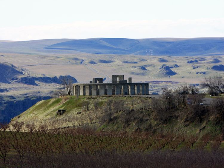
Hill used his Maryhill property to build the first paved roads in the Pacific Northwest, the Maryhill Museum of Art (originally intended as a grand residence for the Hills), Maryhill Stonehenge, a monument to the World War I dead of Klickitat County in the form of a Stonehenge replica, and a planned community. Born a Quaker, Hill hoped to attract a Quaker community to eastern Washington. His plans never materialized, and the town buildings he constructed burned down several years later.
Hill intended the Stonehenge replica to express that modern warfare (like Druid sacrifices as he understood them) was a form of needless human sacrifice.
Geography
Maryhill is located at 45°41′8″N 120°49′2″W (45.685649, -120.817232).
According to the United States Census Bureau, the CDP has a total area of 2.8 square miles (7.3 km²), all land.
Demographics
As of the census of 2000, there were 98 people, 40 households, and 26 families residing in the CDP. The population density was 35.0 people per square mile (13.5/km²). There were 49 housing units at an average density of 17.5/sq mi (6.8/km²). The racial makeup of the CDP was 77.55% White, 9.18% African American, 2.04% Native American, 1.02% Pacific Islander, 1.02% from other races, and 9.18% from two or more races. Hispanic or Latino of any race were 9.18% of the population.
There were 40 households out of which 30.0% had children under the age of 18 living with them, 57.5% were married couples living together, 5.0% had a female householder with no husband present, and 35.0% were non-families. 22.5% of all households were made up of individuals and 10.0% had someone living alone who was 65 years of age or older. The average household size was 2.45 and the average family size was 2.92.
In the CDP, the population was spread out with 22.4% under the age of 18, 4.1% from 18 to 24, 27.6% from 25 to 44, 29.6% from 45 to 64, and 16.3% who were 65 years of age or older. The median age was 40 years. For every 100 females there were 113.0 males. For every 100 females age 18 and over, there were 123.5 males.
The median income for a household in the CDP was $37,250, and the median income for a family was $48,529. Males had a median income of $36,103 versus $28,750 for females. The per capita income for the CDP was $18,939. None of the population or families were below the poverty line.