
Status Open Date closed 1939 | Date restored 1974 Date completed 1831 | |
 | ||
Macclesfield peak forest canals marple junction
Marple Junction (grid reference SJ961884) is the name of the canal junction where the Macclesfield Canal terminates and meets the Peak Forest Canal at Marple, Greater Manchester, England.
Contents
- Macclesfield peak forest canals marple junction
- Stalham and betelgeuse at marple junction
- History
- Location
- References
The water of the two canal companies was kept apart by a stop lock in the narrows at the end of the later Macclesfield Canal, but this has long since been de-gated, and the two canals run at the same level.
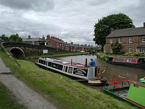
Stalham and betelgeuse at marple junction
History
The Peak Forest Canal was authorised by an Act of Parliament obtained in 1794, which was designed to access the limestone deposits at Doveholes, near Whaley Bridge. The canal ran from Dukinfield Junction on the Ashton Canal to Bugsworth Basin, from where a tramway ran the final 6.5 miles (10.5 km) to the quarries, which were over 1,000 feet (300 m) above sea level. There were two level pounds on the canal, separated by a flight of 16 locks, which raised the level by 214 feet (65 m). Most of the canal opened in 1800, but the locks were not completed until 1804, and a second tramway was used to bypass the locks until they were ready.
Although a route through Macclesfield to connect the Trent and Mersey Canal to Manchester had been suggested as early as 1777, an Act of Parliament was not obtained until 1826, following a survey by Thomas Telford. The canal opened on 9 November 1831, and like the Peak Forest, was built as two level sections, with a flight of locks between them, in this case the twelve Bosley locks, which raise the level by 118 feet (36 m). The junction with the Peak Forest Canal is just above the top lock of the Marple flight.
The limestone traffic on the upper Peak Forest Canal ceased in 1922, and the upper section gradually became unusable. The lower canal was also disused by 1939. Following determined efforts by the Peak Forest Canal Society, the Inland Waterways Association, the British Waterways Board and the local authorities through whose regions the canals ran, both the Peak Forest Canal and the Ashton Canal, which provided its connection to the national network, were reopened in 1974. With the reopening, the junction was again operational.
Location
The top lock of the Marple flight is immediately to the north of the junction. From the bottom of the locks, the canal passes through Hyde Bank Tunnel and Woodley Tunnel to reach Dukinfield Junction, 8 miles (13 km) away. To the south-east, the canal is level for 6.7 miles (10.8 km) to its terminus at Bugsworth Basin, which has been restored by the Inland Waterways Protection Society. The Macclesfield Canal initially heads south-west before turning to the south. A footbridge carries the towpath from the west bank of the Peak Forest Canal to the south bank by the junction, but it very quickly crosses back to the western bank of the Macclesfield Canal at Church Lane Bridge. The canal is level for 16.1 miles (25.9 km) to the top of the Bosley flight, and continues on to reach Hall Green stop lock, its junction with the Trent and Mersey Canal, at 26.1 miles (42.0 km). The whole of the canal is a designated conservation area, following action by Macclesfield Borough Council in June 1975, as a response to a policy document entitled Recreational Framework for Britain's Canals.