
Country United States Time zone Mountain (MST) (UTC-7) Local time Sunday 2:05 PM | State Arizona Elevation 1,093 ft (333 m) FIPS code 04-44585 Area code 520 | |
 | ||
Weather 31°C, Wind W at 8 km/h, 15% Humidity | ||
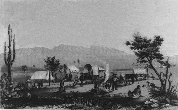
Maricopa Wells is a populated place situated in Pinal County, Arizona. It has an estimated elevation of 1,093 feet (333 m) above sea level. Historically, it was an oasis around a series of watering holes in the Sierra Estrella, eight miles north of present-day Maricopa, Arizona, and about a mile west of Pima Butte. It developed as a trading center and stopping place for travelers in the mid to late 19th century.
Contents
Map of Maricopa Wells, Arizona 85339, USA
History
Maricopa Wells was a watering place named by travelers on the Southern Emigrant Trail who used it as a stopping place on the trail. They could rest and feed and water their animals. They traded with the nearby Maricopa and Pima natives for crops produced in their fields, which they irrigated by the Gila River. A settlement developed here when it was the base for the large stage station for the San Antonio-San Diego Mail Line and Butterfield Overland Mail, and later stage companies. At one time this was the primary military telegraph post for all of Arizona Territory.
It was abandoned after the railroad constructed a route north through Tempe to Phoenix. Maricopaville was planned as a terminus before Tempe won a spot on the line that was constructed. The settlement moved east to what developed as Maricopa Junction, known as Maricopa.