
 | ||
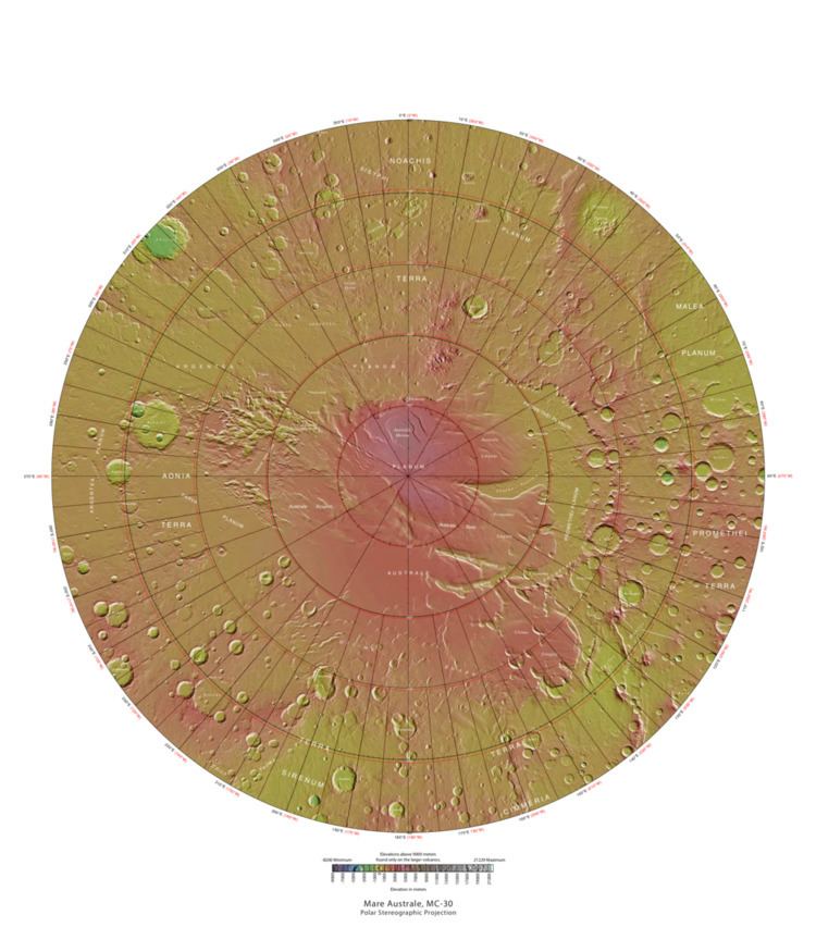
The Mare Australe quadrangle is one of a series of 30 quadrangle maps of Mars used by the United States Geological Survey (USGS) Astrogeology Research Program. The Mare Australe quadrangle is also referred to as MC-30 (Mars Chart-30). The quadrangle covers all the area of Mars south of 65°, including the South polar ice cap, and its surrounding area. The quadrangle's name derives from an older name for a feature that is now called Planum Australe, a large plain surrounding the polar cap. The Mars polar lander crash landed in this region.
Contents
Notable features
Around the southern ice cap is a surface, called the Dorsa Argentea Formation that may be an old ice-rich deposit. It contains a group of sinuous, branched ridges that resembles eskers that form when streams are under glaciers. The formation often contains pits: two major locations are named Cavi Angusti and Cavi Sisyphi. The pits have steep sides and an irregular shape. They are up to 50 km across and 1 km deep.
The quadrangle also contains Angustus Labyrinthus, a formation of intersecting valley or ridges, nicknamed the "Inca City". Researchers were surprised to see parts of the surface having a Swiss-cheese appearance. Also, some areas showed strange spider-shaped forms, which were determined to be caused by carbon dioxide gas blowing dust around at certain times of the year.
Some craters in Mare Australe show gullies. Martian gullies are small, incised networks of narrow channels and their associated downslope sediment deposits, found on the planet of Mars. They are named for their resemblance to terrestrial gullies. First discovered on images from Mars Global Surveyor, they occur on steep slopes, especially on the walls of craters. Usually, each gully has a dendritic alcove at its head, a fan-shaped apron at its base, and a single thread of incised channel linking the two, giving the whole gully an hourglass shape. They are believed to be relatively young because they have few, if any craters. A subclass of gullies is also found cut into the faces of sand dunes which themselves considered to be quite young. On the basis of their form, aspects, positions, and location amongst and apparent interaction with features thought to be rich in water ice, many researchers believed that the processes carving the gullies involve liquid water. However, this remains a topic of active research. As soon as gullies were discovered, researchers began to image many gullies over and over, looking for possible changes. By 2006, some changes were found. Later, with further analysis it was determined that the changes could have occurred by dry granular flows rather than being driven by flowing water. With continued observations many more changes were found in Gasa Crater and others. With more repeated observations, more and more changes have been found; since the changes occur in the winter and spring, experts are tending to believe that gullies were formed from dry ice. Before-and-after images demonstrated the timing of this activity coincided with seasonal carbon-dioxide frost and temperatures that would not have allowed for liquid water. When dry ice frost changes to a gas, it may lubricate dry material to flow especially on steep slopes. In some years frost, perhaps as thick as 1 meter.
Freezing of atmosphere
Research based on slight changes in the orbits of spacecraft around Mars over 16 years found that when one hemisphere experiences winter, approximately 3 trillion to 4 trillion tons of carbon dioxide freezes out of the atmosphere onto the northern and southern polar caps. This represents 12 to 16 percent of the mass of the entire Martian atmosphere. These observation support predictions from the Mars Global Reference Atmospheric Model -- 2010.
Spiders
During the winter, much frost accumulates. It freezes out directly onto the surface of the permanent polar cap, which is made of water ice covered with layers of dust and sand. The deposit begins as a layer of dusty CO
2 frost. Over the winter, it recrystalizes and becomes denser. The dust and sand particles caught in the frost slowly sink. By the time temperatures rise in the spring, the frost layer has become a slab of semi-transparent ice about 3 feet thick, lying on a substrate of dark sand and dust. This dark material absorbs light and causes the ice to sublimate (turn directly into a gas) below the surface. Eventually much gas accumulates and becomes pressurized. When it finds a weak spot, the gas escapes and blows out the dust. Speeds can reach 100 miles per hour. Dark channels can sometimes be seen; they are called "spiders." The surface appears covered with dark spots when this process is occurring. These features can be seen in some of the pictures below.
Dorsa Argentea Formation
The Dorsa Argentea Formation (DAF) is thought to be a large system of eskers that were under an ancient ice cap in the south polar region of Mars. This group of ridges extends from 270–100 E and 70–90 S, around the south pole of Mars. It sits under the Late Amazonian South Polar Layered Deposits (SPLD). The amount of these ridges is huge, one study studied seven different ridge systems which contained almost 4,000 ridges that had a total length 51,000 km.
Most eskers are thought to be formed inside ice-walled tunnels by streams which flowed within and under glaciers. After the retaining ice walls melted away, stream deposits remained as long winding ridges.
MARSIS radar data suggest that significant areas of layered, potentially ice-rich parts of the Dorsa Argentea Formation remain today.
Proof for ocean
Strong evidence for a one time ancient ocean was found from data gathered from the north and south poles. In March 2015, a team of scientists published results showing that this region was highly enriched with deuterium, heavy hydrogen, by seven times as much as the Earth. This means that Mars has lost a volume of water 6.5 times what is stored in today's polar caps. The water for a time would have formed an ocean in the low-lying Mare Boreum. The amount of water could have covered the planet about 140 meters, but was probably in an ocean that in places would be almost 1 mile deep.
This international team used ESO’s Very Large Telescope, along with instruments at the W. M. Keck Observatory and the NASA Infrared Telescope Facility, to map out different forms of water in Mars’s atmosphere over a six-year period.
Swiss Cheese Terrain
Parts of Mare Australe display pits that make the surface look like swiss cheese. These pits are in a 1-10 meter thick layer of dry ice that is sitting on a much larger water ide cap. Pits have been observed to begin with small areas along faint fractures. The circular pits have steep walls that work to focus sunlight, thereby increasing erosion. For a pit to develop a steep wall of about 10 cm and a length of over 5 meters in necessary.