
Population 1,379 (2011) Community Marchwiel Sovereign state United Kingdom Local time Tuesday 2:28 AM | OS grid reference SJ356476 Country Wales Postcode district LL13 Dialling code 01978 | |
 | ||
Weather 4°C, Wind W at 27 km/h, 75% Humidity Neighborhoods Stryt-yr-hwch, Cock Bank, Old Sontley | ||
Marchwiel (Welsh: Marchwiail) is a village and a local government community, the lowest tier of local government, part of Wrexham County Borough in Wales.
Contents
Map of Marchwiel, Wrexham, UK
It is about 2 miles south-east of Wrexham town on the A525 road towards Bangor-on-Dee. The community has an area of 1,488 hectares and a population of 1,418 (2001 census), the population falling to 1,379 at the 2011 Census.
There are several large country houses in the area including Marchwiel Hall, Bryn-y-grog, Old Sontley and Erddig Hall, now a National Trust property and a popular tourist attraction. The 19th century, Marchwiel Hall was acquired by Sir Alfred McAlpine, founder of Alfred McAlpine and son of 'Concrete' Bob McAlpine.
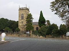
In the Middle Ages there was a church at Marchwiel dedicated to Saint Deiniol. The Welsh name of the village means "strong twigs", referring to the material used to build the first church. The current church building dates from 1778 and is dedicated to Saint Marcella. The church contains a number of memorials to members of the Yorke family of Erddig and has a stained-glass window showing the Yorke family tree.
Governance
An electoral ward in the same name exists. This ward includes Erbistock and at the 2011 census had a total population of 2,371.