
NRHP Reference # 03000312 Area 9 ha | Dates of significance 1781, 1782 Added to NRHP 6 June 2003 | |
 | ||
MPS Rochambeau's Army in Connecticut, 1780-1782 MPS | ||
March Route of Rochambeau's Army: Plainfield Pike is a 3.6 mile long road segment in Plainfield, Connecticut and Sterling, Connecticut, that is a portion of the historic march route of Comte de Rochambeau's army in June 1781 on its way to Yorktown, Virginia, and again of the returning army in November 1782. It was listed on the National Register of Historic Places (NRHP) in 2003.
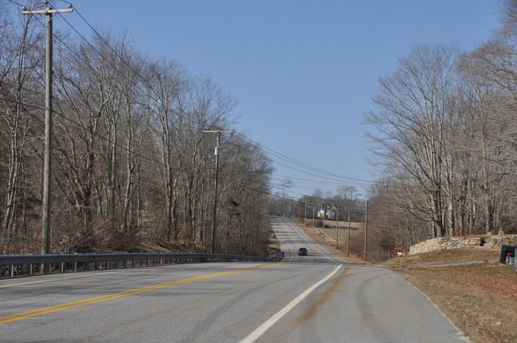
It is a linear historic district consisting of a portion of Connecticut Route 14A, locally known as Plainfield Pike, which is level in the eastern part but generally hilly with curves. Along the route is open land including pasture and cornfields, wooded areas, and streams including Ekonk Brook. It is bordered by stone walls about 50 feet apart, on both sides, for most of the way. As of 2002, the walls, overgrown in places, were clearly visible at some times of the year but difficult to see in the summer. The only concentration of houses, as of 2002, was of period (18th century) and later but still historic (19th-century) houses in the Sterling Hill Historic District section. Among these is the Dorrance Inn, in Sterling (then part of the town of Voluntown), which was mentioned in multiple French accounts of the marches, and which is also NRHP-listed. The segment includes views of farm fields and other countryside suggestive of how the land would have appeared in 1781 and 1782 for the troops marching through, including views west to ridges on the west side of the Quinebaug River valley. According to the NRHP nomination for the district:
Although it is now a paved state highway, the road retains its narrow, hilly, winding character, and for most of its length, the characteristic borders of stone walls remain in place. This is the longest continuous portion of the route to survive with these physical attributes intact. This is also the only portion of the route that still offers repeated vistas of distant ridges (Photographs 3 and 4). Elsewhere, the route has been too affected by re-forestation to allow such views.
The area listed is the roadway, owned by the Connecticut State Department of Transportation, and not the adjacent properties. In 1781 the roadway was poor, at least to the east of the hamlet of Plainfield (just east of the listed district) and caused difficulty for the artillery and baggage trains making their way from the army's second camp, near Waterman's Tavern in Rhode Island, to Plainfield. One Frenchman (Clermont-Crevecoeur)'s journal recorded
"very bad roads. The artillery and the supply wagons arrived [at the Plainfield camp] very late" (Rice and Brown 1972 (I): 28). Von Closen agreed: "The roads were still very bad" (von Closen 1958: 85), as did du Bourg: "The roads still quite bad, many stragglers" (du Bourg, Vol. 4 (April 1880): 293).
Multiple other properties whose association with Rochambeau's route is known were also considered for listing on the National Register in a 2001 study.