
Basin size 1,066 km (412 sq mi) | Length 80 km | |
 | ||
Main source Turimiquire Rangeca 2,000 m (6,600 ft) River mouth Cariaco Gulf, Caribbean0 m (0 ft) Discharge Average rate:17.48 m/s (617 cu ft/s) | ||
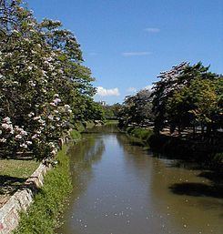
The Manzanares is an 80 km long river in Venezuela. It flows into the Caribbean Sea.
Contents
Map of Rio Manzanares, Venezuela
Course
The source of the Manzanares is at the 2,200 m high Turimiquire Range in Sucre State. The river flows roughly northwards for about 80 km by the city of Cumanacoa. Finally it flows by Cumaná into the Cariaco Gulf of the Caribbean.
History
Historically this river had also been known as the 'Cumaná River', for it has an iconic value in the city of Cumaná.
Alexander von Humboldt praised the pleasant atmosphere of the river banks in his travelogue Personal Narrative of a Journey to the Equinoctial Regions of the New Continent (1814–29)
In 2012 Hurricane Isaac caused heavy rain in the area and the Manzanares overflowed its banks in the town of Cumanacoa inundating approximately 1,200 homes many of which were damaged and a few destroyed. Some residents had to be airlifted to safety. Similar flooding occurred elsewhere in the country, such as in Caracas where 40 families had to be evacuated.
This river is the subject of Rio Manzanares, a famous Parang song composed by José Antonio López in Cumaná in 1958.