
Sovereign state United Kingdom Postcode district LS15 Dialling code 0113 | Post town Leeds | |
 | ||
Region | ||
Manston is an area to the east of Cross Gates, Leeds, England, that lies 4 miles (6 km) to the east of Leeds city centre. It is East of the Ring Road, North of Austhorpe Road and South of Barwick Road. The area falls within the Cross Gates and Whinmoor ward of Leeds Metropolitan Council. It is named after the former Manston estate of the Gascoigne family. Many streets in the area are named after Manston, such as Manston Crescent and Manston Grove.
Map of Manston, Leeds, UK
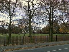
It contains Barnbow, the site of a munitions factory in both World Wars, and now a scheduled monument. It has its own park, Manston Park, and had a pub named after it, the Manston hotel, which is now known as The Barnbow, next to the park. It has a Parish Church, St James the Great, and is also home to three primary schools, Manston Primary, Manston St James Primary Academy and St Theresa's Catholic Primary.