
Airport type Public Elevation AMSL 51 ft / 16 m 2,720 829 Code KMO | 1/19 2,720 Elevation 16 m Phone +1 907-269-0767 | |
 | ||
Owner State of Alaska DOT&PF - Central Region Address Togiak National Wildlife Refuge, Manokotak, AK 99628, USA | ||
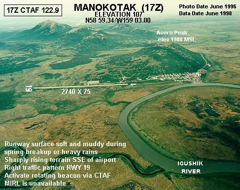
Manokotak Airport (IATA: KMO, ICAO: PAMB, FAA LID: MBA, formerly 17Z) is a state-owned public-use airport located one mile (2 km) north of the central business district of Manokotak, a city in the Dillingham Census Area of the U.S. state of Alaska.
Although most U.S. airports use the same three-letter location identifier for the FAA and IATA, Manokotak Airport is assigned MBA by the FAA and KMO by the IATA (which assigned MBA to Moi International Airport in Mombasa, Kenya).
Facilities and aircraft
Manokotak Airport has one runway designated 1/19 with a 2,720 x 60 ft (829 x 18 m) gravel surface. For the 12-month period ending December 31, 2001, the airport had 1,200 aircraft operations: 83% air taxi and 17% general aviation.
References
Manokotak Airport Wikipedia(Text) CC BY-SA