
Country Japan Website www.city.maniwa.lg.jp Population 50,389 (1 Sep 2011) Prefecture Okayama Prefecture | Region Chūgoku (San'yō) Area 828.4 km² Local time Monday 3:46 PM | |
 | ||
Time zone Japan Standard Time (UTC+9) City hall address 2927-2 Kuse, Maniwa-shi, Okayama-ken
719-3292 Weather 12°C, Wind SE at 18 km/h, 49% Humidity Points of interest Yubara Hot Spring, Hiruzen Kogen Center Jo, Kanbano Falls, Kanbanotaki Natural Park, Yuhara Hot Spring Museum | ||
Maniwa (真庭市, Maniwa-shi) is a city located in north-central Okayama Prefecture, Japan.
Contents
- Map of Maniwa Okayama Prefecture Japan
- Geography
- Adjoining municipalities
- Railways
- Road
- Sister and Friendship cities
- Notable places and events
- Festivals
- Onsens
- References
Map of Maniwa, Okayama Prefecture, Japan
The modern city of Maniwa was established on March 31, 2005, from the merger of the town of Hokubō (from Jōbō District); the towns of Katsuyama, Ochiai, Yubara and Kuse, and the villages of Mikamo, Kawakami, Yatsuka and Chūka (all from Maniwa District).
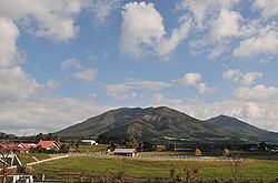
On September 1, 2011, Maniwa has an area of 828.43 km², the largest area of any municipality in the prefecture. Its population was 50,389, with 17,711 households. The city is known for Mount Hiruzen (1,202 m (3,944 ft)) and the Hiruzen Plateau. Mount Hiruzen is also the source of the Asahi River (142 kilometres (88 mi)), which flows through much of Okayama Prefecture.
Geography
Maniwa is located in approximately the center of the Chūgoku Mountains. The mountainous part of the city is dominated by Mount Hiruzen. The Asahi River, a Class 1 river under the Rivers Act of 1964, emerges from Mount Hiruzen in Maniwa, and its upper reaches are located within the town. The river has approximately 146 tributaries. Major tributaries of the Asahi in Maniwa include the Bitchū, Nakazui, Kōchi, Meki, and the Shinjō rivers.
Adjoining municipalities
Railways
The main station is Chūgoku-Katsuyama.