
Area 48,282 km² Number of airports 1 | Time zone UTC-4 (UTC-4) Local time Monday 12:11 AM | |
 | ||
Weather 23°C, Wind N at 3 km/h, 95% Humidity | ||
Manicoré is a municipality located in the south-east of the Brazilian state of Amazonas.
Contents
Map of Manicor%C3%A9 - State of Amazonas, Brazil
Location
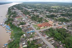
The population of Manicoré was 38,148 (2005) and its area is 48,282 km². The town is located on the banks of the Madeira River about 3 km (1.9 mi) downstream from where the Manicoré River merges into the Madeira.
The city is served by Manicoré Airport.
Economy
Santo Antônio do Matupí is a major centre of logging in the region.
Conservation
The municipality contains the 304,146 hectares (751,560 acres) Lago do Capanã Grande Extractive Reserve, created in 2004. It contains 15% of the 283,117 hectares (699,600 acres) Rio Madeira Sustainable Development Reserve, created in 2006. It contains about 15% of the Campos Amazônicos National Park, a 961,318 hectares (2,375,470 acres) protected area created in 2006 that protects an unusual enclave of cerrado vegetation in the Amazon rainforest. It contains about 10% of the 513,747 hectares (1,269,500 acres) Matupiri State Park, created in 2009 along the Matupiri River. It contain 22% of the 397,557 hectares (982,380 acres) Igapó-Açu Sustainable Development Reserve, also created in 2009.
The municipality contains about 55% of the 359,138 hectares (887,450 acres) Manicoré Biological Reserve, created by decree in May 2016 in the week before the provisional removal of president Dilma Rousseff. The municipality also contains the 151,993 hectares (375,580 acres) Campos de Manicoré Environmental Protection Area, created at the same time. The purpose was to protect biological diversity and control the process of occupying the region, in particular along the road being built between Santo Antônio de Matupi on BR-230 and the seat of the municipality of Manicoré on the Madeira River. The municipality contains about 9% of the 751,302 hectares (1,856,510 acres) Aripuanã National Forest, a sustainable development unit also created at that time.