
Constituted April 20, 1904 Area 339.3 km² | Settled 1824 Time zone EST (UTC−5) Province Québec | |
 | ||
Mandeville is a municipality in the D'Autray Regional County Municipality in the Lanaudière region of Quebec, Canada.
Contents
Map of Mandeville, QC, Canada
Topography
Prior to June 2, 2001, it was officially known as Saint-Charles-de-Mandeville.
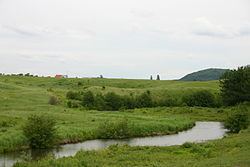
The town itself is located along the Mastigouche River, just north of Lake Maskinongé. The municipal territory is dotted with lakes, many of which are lined with cottages. The northern portion is undeveloped and part of the Mastigouche Wildlife Reserve. Mandeville is considered a paradise for hunting and trapping (bear, moose, wolf, lynx) and fishing (musky, trout, bass).
Mandeville is home to the Pléïades Observatory, managed by Centre d'Observation et de Recherche Astronomique Mandeville (C.O.R.A.M. Inc.).
History
In the early 19th century, the territory was part of the Hope Fief. This fief, with an area of 20,000 arpents (68.4 km²) was granted to Angélique Blondeau by Seignoral Lord Charles-Louis Tarieu de Lanaudière, but was mostly neglected by the seignoral lords. In 1824, one of the first settlers, Maximillien or Maxime Mandeville, arrived at the shores of the lake that today bears his name. And in 1837, further colonization occurred when a large group of settlers came from Maskinongé, Berthierville, and Sorel.
In 1894, the Mission of Saint-Charles-de-Mandeville was formed and became a parish in 1903. The name is most likely a reference to Charles Turgeon, pastor of the nearby parish of Saint-Didace, who worked extensively in Mandeville. In 1904, the Municipality of Saint-Charles-de-Mandeville was established and in 1905, its post office opened.
Since the toponym "Saint-Charles" had not been in common use for a long time, the municipality officially abbreviated its name to Mandeville in 2001. Soon after, the municipal boundary between Mandeville and Saint-Damien was reorganized, and Mandeville gained about 146 square kilometres (56 sq mi).
Demographics
Population trend:
Private dwellings occupied by usual residents: 1005 (total dwellings: 1770)
Mother tongue:
Mayors
The mayors of Mandeville were: