
Country United States Incorporated 1645 Zip code 01944 | State Massachusetts Settled 1629 Elevation 30 ft (9 m) Population 5,136 (2010) | |
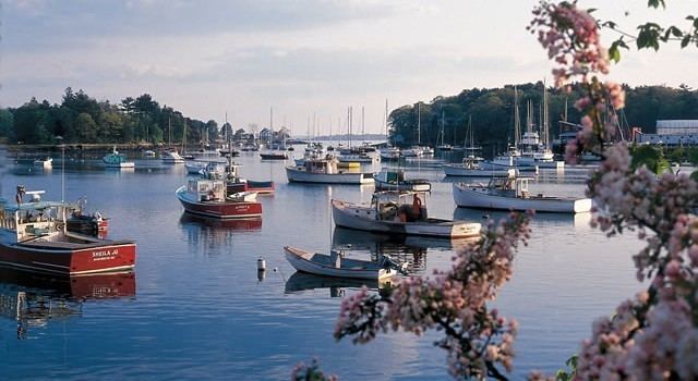 | ||
Weather 3°C, Wind NE at 27 km/h, 57% Humidity Points of interest Singing Beach, Masconomo Park, Coolidge Reservation | ||
Manchester by the sea massachusetts ma real estate tour
Manchester-by-the-Sea (or simply Manchester) is a town on Cape Ann, in Essex County, Massachusetts, in the United States. The town is known for scenic beaches and vista points. At the 2010 census, the town population was 5,136.
Contents
- Manchester by the sea massachusetts ma real estate tour
- Map of Manchester by the Sea MA 01944 USA
- History
- Name
- Geography
- Demographics
- Media
- Singing Beach
- Other points of interest
- Notable people
- References
Map of Manchester-by-the-Sea, MA 01944, USA
History
Manchester was first settled by Europeans in 1629 and was officially incorporated in 1645. It was formed out of territory taken from Salem (that portion since given to Beverly) and Gloucester.
The community thrived primarily as a fishing community for over 200 years. Its economy shifted to that of a Boston area summer colony starting in 1845, when Richard Dana, a Boston-based poet, built a house in the town. Over the next fifty years, development of summer houses along the coastline established the community as Boston society's community of choice for summer residency. The trend continued with designs by other notable architects, such as "Sunny Waters", designed by John Hubbard Sturgis for his older brother, Russell, in 1862.
The most famous of these "summer cottages" was Kragsyde, built on Smith's Point in 1883 and demolished in 1929. Commissioned by George Nixon Black, the Peabody and Stearns-designed residence has been hailed as the zenith of the Shingle style substyle of the Queen Anne style of architecture.
Name
To prevent confusion with the nearby and much larger city of Manchester, New Hampshire, the name of the town was officially changed in 1989 following a close town meeting vote that year and an act of the state legislature passed on September 25, 1989.
The name change was driven by Edward Corley, a longtime resident of Manchester. All town documents, and the town seal, now use the name "Manchester-by-the-Sea", and as a result of some minor resident activism, so do the majority of public and private lists of Massachusetts cities and towns, including that of the state government.
Geography
According to the United States Census Bureau, the town has a total area of 18.3 square miles (47.3 km2), of which 9.2 square miles (23.9 km2) is land and 9.0 square miles (23.4 km2), or 49.47%, is water. The town lies along the North Shore of Massachusetts Bay, which in turn leads to the Atlantic Ocean. There are seven beaches lining the coast, and several small islands dot the coast, the largest being Kettle Island and House Island.
Several small coves line the coast, the largest being Manchester Harbor, which is fed by Sawmill Brook and other small brooks. There are several protected areas within town, including Cedar Swamp Conservation Area, Cheever Commons Conservation Area, Coolidge Reservation, Dexter Pond, Owl's Nest Nature Preservation Land, Powder House Hill Reservation, and Wyman Hill Conservation Area.
Manchester-by-the-Sea is bordered by Beverly and Wenham to the west, Hamilton to the northwest, Essex to the north, and Gloucester to the east. The town is located 9 miles (14 km) northeast of Salem and 24 miles (39 km) northeast of Boston. Manchester-by-the-Sea lies along Massachusetts Route 128, which has two exits within town as it passes from Beverly to Gloucester, with a small portion crossing through the corner of Essex. Route 127 also passes from west to east through town, traveling through the center of town. There is no bus service directly into town, with service passing east via the Cape Ann Transportation Authority in Gloucester and MBTA Bus, which provides service to Beverly.
The town is served by a stop along the Newburyport/Rockport Line of the MBTA Commuter Rail, providing service from Rockport along the North Shore to Boston's North Station. The nearest airport is the Beverly Municipal Airport, with the nearest national and international service at Boston's Logan International Airport.
Demographics
As of the census of 2010, there were 5,136 people, 2,147 households, and 1,444 families residing in the town. The population density was 562.7 people per square mile (217.3/km²). There were 2,276 housing units at an average density of 250.5 per square mile (96.7/km²). The racial makeup of the town was 97.6% White, .1% African American, 0.2% Native American, 0.9% Asian, 0.1% from other races, and 1.1% from two or more races. Hispanic or Latino of any race were 1.5% of the population.
There were 2,147 households out of which 29.5% had children under the age of 18 living with them, 56.6% were married couples living together, 8.4% had a female householder with no husband present, and 32.7% were non-families. 28.8% of all households were made up of individuals and 13.7% had someone living alone who was 65 years of age or older. The average household size was 2.39 and the average family size was 2.96.
In the town, the population was spread out with 25.1% under the age of 19, 3.0% from 20 to 24, 17.2% from 25 to 44, 34.9% from 45 to 64, and 16.6% who were 65 years of age or older. The median age was 47.6 years.
The median income for a household in the town was $95,243, and the median income for a family was $109,760. Males had a median income of $89,125 versus $56,579 for females. The per capita income for the town was $68,228. About 4.5% of families and 5.1% of the population were below the poverty line, including 3.9% of those under age 18 and 3.7% of those age 65 or over.
Media
The local newspaper, The Manchester Cricket, is published weekly. The town is also served by the regional newspaper the Gloucester Daily Times.
Singing Beach
One mile from the town center is Singing Beach, so named because the sand comprising the beach squeaks when walked upon (see Singing sand). This beach is quite popular during summer months in particular because it is easily accessible from Boston by a half-mile walk from the MBTA train station. Also located on this historic beach is the famous tourist attraction "Eaglehead", a rock composite that is the focal point of rock climbing and other recreation activities.