
River mouth Tasman Sea
sea level Discharge 102 m³/s | Length 180 km Country New Zealand | |
 | ||
Manawatu floods 2015 footage video pahiatua track manawatu river aokautere
The Manawatu River is a major river of the lower North Island of New Zealand.
Contents
- Manawatu floods 2015 footage video pahiatua track manawatu river aokautere
- Map of Manawatu River Manawatu Wanganui New Zealand
- Manawatu river in flood palmerston north 21 june 2015
- Physical environmentEdit
- Water qualityEdit
- References
Map of Manawatu River, Manawatu-Wanganui, New Zealand
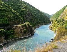
The river has its headwaters to the northwest of Norsewood in the Ruahine Ranges of the Tararua District. It flows initially eastward before turning south-west near Ormondville, flowing 40 kilometres (25 mi) before turning north-west near Woodville. At this point the river enters the Manawatu Gorge. Beyond the gorge it again turns south-west, flowing through the city of Palmerston North, and finally becomes the Manawatu Estuary as it enters the Tasman Sea at Foxton Beach.
The river, along with the more northern Whanganui River, gives its name to the Manawatu-Whanganui region. The river's name comes from the Māori words manawa (heart, spirit) and tū (stand still, or depressed), therefore heart standing still with fear, or depressed spirit. Haunui was in pursuit of his wife and arrived at this river clutching his chest when he named this river.
Manawatu river in flood palmerston north 21 june 2015
Physical environmentEdit
The river is unique among New Zealand rivers, starting on the east side of the main dividing range and having its outflow to the west. The explanation for this is the uplift of the central ranges. The ranges moved upwards at the same time as the gorge was eroded by the river, instead of the more usual erosion of an already existing range. This suggests that the river is an old one, as it must have existed before the Ruahine and Tararua Ranges.
Major tributaries of the river include the Makakahi, Mangahao, Pohangina and Oroua Rivers. The Manawatu's total length is 180 kilometres (110 mi), making it only the 12th-longest in the country, but at 102 cubic metres per second (3,600 cu ft/s) it is one of the country's greatest rivers in terms of flow, and second only to the Waikato River among North Island rivers.
The Manawatu River flooded in February 2004, displacing over 3000 people (primarily from Marton and Feilding) and damaging over 1000 Manawatu farms. The cost of the flood in terms of insurance payouts was NZ$122 million. Further damage was prevented by the opening of the Moutoa floodgates, which intercept the river between Foxton and Shannon.
Water qualityEdit
The Manawatu tops a 2009 pollution measurement of 300 rivers and streams across North America, Europe, Australia and New Zealand, research by the Cawthron Institute has found. The river is fouled with industrial waste, treated sewage, and nutrient land runoff from dairy farms. A 2010 report listed the Manawatu as unsuitable for contact recreation.
In 2006 Fonterra were criticised for an application to discharge 8,500 cubic metres (300,000 cu ft) of wastewater into the Manawatu River. In 2009, the Cawthron Institute found that the river had the highest gross primary production (GPP) compared to 300 rivers and streams in the Western world. High GPP rates are an indication of poor ecological health and can lead to various environmental issues. In 2011, the Horizons Regional Council laid blame with the Palmerston North City Council for "considerable" and "sustained" breaches of one of its discharge consents, and some degree of non-compliance with two others. A report by the Ministry for the Environment ranked 76 New Zealand sites for water clarity and E. coli levels. Using those measures, they found four other New Zealand rivers rate worse than the Manawatu (the Waitara, Whanganui, Waipa and Rangitikei).