
FIPS code 19-48675 Elevation 337 m Local time Sunday 5:45 AM | Time zone Central (CST) (UTC-6) GNIS feature ID 0458746 Area 161 ha Population 29 (2013) | |
 | ||
Weather 4°C, Wind SE at 18 km/h, 67% Humidity | ||
Maloy is a city in Ringgold County, Iowa, United States, along the Platte River. The population was 29 at the 2010 census.
Contents
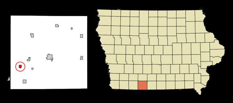
Map of Maloy, IA 50860, USA
History
Settlement of the western part of Ringgold County began in the 1850s. Maloy was platted in 1887, in the same year as the railroad arrived. Maloy was incorporated as a city in 1901. In 1917, the two-story brick Maloy High School was built; after serving from 1920 to 1952, it became an elementary school in the Mount Ayr Community School District.
A major fire on June 17, 1931, razed the Catholic Church, five businesses, a house, and a barn. The school closed in 1972 and was torn down in 1987. The railroad, which once offered both freight and passenger service, was dismantled in 1985.
Today, the city is governed by a mayor and three-member city council.
Geography
Maloy's longitude and latitude coordinates
in decimal form are 40.674921, -94.413057.
According to the United States Census Bureau, the city has a total area of 0.62 square miles (1.61 km2), all of it land.
2010 census
As of the census of 2010, there were 29 people, 12 households, and 10 families residing in the city. The population density was 46.8 inhabitants per square mile (18.1/km2). There were 15 housing units at an average density of 24.2 per square mile (9.3/km2). The racial makeup of the city was 100.0% White.
There were 12 households of which 33.3% had children under the age of 18 living with them, 75.0% were married couples living together, 8.3% had a male householder with no wife present, and 16.7% were non-families. 16.7% of all households were made up of individuals and 8.3% had someone living alone who was 65 years of age or older. The average household size was 2.42 and the average family size was 2.60.
The median age in the city was 42.5 years. 20.7% of residents were under the age of 18; 13.7% were between the ages of 18 and 24; 24% were from 25 to 44; 20.5% were from 45 to 64; and 20.7% were 65 years of age or older. The gender makeup of the city was 62.1% male and 37.9% female.
2000 census
As of the census of 2000, there were 28 people, 10 households, and 7 families residing in the city. The population density was 45.1 people per square mile (17.4/km²). There were 11 housing units at an average density of 17.7 per square mile (6.9/km²). The racial makeup of the city was 100.00% White.
There were 10 households out of which 50.0% had children under the age of 18 living with them, 50.0% were married couples living together, 10.0% had a female householder with no husband present, and 30.0% were non-families. 20.0% of all households were made up of individuals and 10.0% had someone living alone who was 65 years of age or older. The average household size was 2.80 and the average family size was 3.29.
In the city, the population was spread out with 32.1% under the age of 18, 7.1% from 18 to 24, 28.6% from 25 to 44, 14.3% from 45 to 64, and 17.9% who were 65 years of age or older. The median age was 36 years. For every 100 females there were 86.7 males. For every 100 females age 18 and over, there were 90.0 males.
The median income for a household in the city is $36,250, and the median income for a family was $13,750. Males had a median income of $16,250 versus $11,875 for females. The per capita income for the city was $10,386. There were 50.0% of families and 42.9% of the population living below the poverty line, including 55.6% of under eighteens and none of those over 64.