
OS grid reference SD896639 | ||
 | ||
Similar Gordale Scar, Malham Tarn, Janet's Foss, Yorkshire Dales, Ingleborough | ||
Landscape photography shoot snow at malham cove after work north yorkshire uk
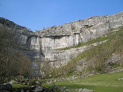
Malham Cove is a limestone formation 0.6 miles (1 km) north of the village of Malham, North Yorkshire, England. The large, curved feature was formed by a waterfall carrying meltwater from glaciers at the end of the last Ice Age more than 12,000 years ago. Today it is a well-known beauty spot within the Yorkshire Dales National Park. A large limestone pavement is above the cove.
Contents
- Landscape photography shoot snow at malham cove after work north yorkshire uk
- Map of Malham Cove Skipton UK
- Yorkshire dales country walk malham gordale scar malham tarn malham cove round
- Geology
- History
- Media appearances
- References
Map of Malham Cove, Skipton, UK
Yorkshire dales country walk malham gordale scar malham tarn malham cove round
Geology
The cove was formed by a large Ice-age river that fell at this point as a cataract. The water drop was 80 m (260 ft) high and more than 300 m (980 ft) wide. The colossal amount of water flowing over the waterfall created the curved shape of the cove because the lip was more heavily eroded than the sides.
Today the water course is marked by a stream that flows out of Malham Tarn 1.5 mi (2.4 km) north of the cove. It becomes a subterranean stream at 'Water Sinks' about 1 mile (1.6 km) before the top of the cove. Another stream named Malham Beck emerges from a cave at the bottom of the cove. The two streams were once thought to be one and the same. However, experiments with dyes have shown that they are two separate waterways that go underground at different locations. Their paths cross without mixing behind the limestone cliff re-emerging a few miles apart. The experiments show that there is complex system of caves and tunnels within the limestone cliff. The system is estimated to be about 50,000 years old. Cave divers, entering the system through the cave at the base of the cove, have so far explored about 1 mi (1.6 km).
The cave systems usually carry away any waters before they reach the fall; however, Malham Cove temporarily became a waterfall for what is believed to be the first time in centuries on 6 December 2015, after heavy rainfall from Storm Desmond.
History
The priest and noted antiquary, Thomas West described the cove in 1779 as, "This beautiful rock is like the age-tinted wall of a prodigious castle; the stone is very white, and from the ledges hang various shrubs and vegetables, which with the tints given it by the bog water. & c. gives it a variety that I never before saw so pleasing in a plain rock."
On the west side of the 80 metre (260 foot) high cliff face are about 400 irregular stone steps: these form part of the route of the Pennine Way and lead to an uneven limestone pavement at the top.
Today the cove is very popular with climbers because of its number of climbing routes (many of which can be ascended in the rain). They include easy to hard traditional climbs as well as sport climbing. Due to the cliff's south face, it is a popular venue for rock climbing in winter, its aspect making it a sun trap; in summer, however, the rock face can become unbearably hot.
Media appearances
The cove, along with nearby Gordale Scar, was featured in an episode of the BBC TV series Seven Natural Wonders as one of the natural wonders of Yorkshire.
The Pavement was used as a shooting location for the 1992 film version of Emily Brontë's "Wuthering Heights"
The cove was also featured in the film Harry Potter and the Deathly Hallows (Part 1) as one of the places Hermione and Harry travel to. The scenes were filmed in November 2009.
The limestone pavement and general location of Malham featured in an episode of The Trip starring Steve Coogan and Rob Brydon which aired on BBC2 on 29 November 2010.
The cove is the bridgehead of an alien invasion in Charles Stross’ 2016 novel The Nightmare Stacks.