
Language spoken | State | |
 | ||
Similar places Inorbit Mall, Aksa Beach, Marve Beach, Madh Fort, Sanjay Gandhi National Park | ||
Map of Malad
Malad is a suburb located in the northern part of Mumbai. It is among the Western Suburbs of Mumbai. Malad has a railway station on the Western Line of the Mumbai Suburban Railway, lying between Kandivali station to the north and Goregaon station to the south. The railway tracks of the Western Line divide Malad into Malad(West) and Malad(East).
Contents
- Map of Malad
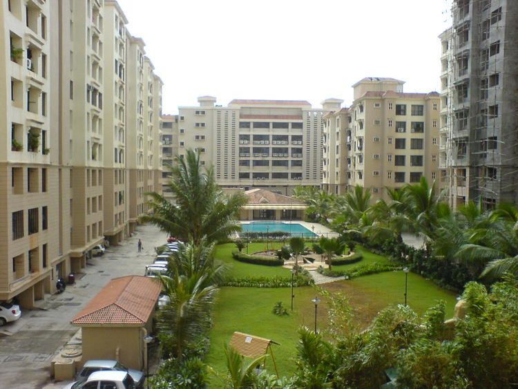
- Omkar alta monte luxurious apartments malad mumbai call09990065550
- History
- Demographics
- Localities
- Education
- Beaches
- Standing outside shanti sweet fast food restaurant lassi centre on station road malad west mumbai maharastra india 3rd february 2012
- References
Until the mid-20th Century, Malad was a sparsely populated suburb cut across by creeks and mangroves. Since the late 20th Century, Malad has become an attractive residential area for white-collar middle-class population from different communities. There were also some small industrial estates. These two developments resulted in the growth of large slums too. Beginning in the early 2000s, Malad witnessed a process of gentrification, with the emergence of large commercial complexes, shopping malls, gated communities, and the large-scale demolition and relocation of slums. Today, Malad is often promoted as "Mumbai's fastest growing suburb".
Omkar alta monte luxurious apartments malad mumbai call09990065550
History
In the 19th century, Malad consisted of a number of villages including Orlem(also known as Valnai), Kharodi, Rathodi, Malwani, Marve, Aksa, Madh and Chinchowli. The other old settlements in Malad were villages occupied by the local East Indian Community, Bhandaris, Kolis, Muslim & South Indian People who are recognized as the original native inhabitants of Mumbai.
The name Malwani is now used to refer to the stretch between BMC Colony Gate No. 1 and Gate No. 8 and further extending to MHADA Colony. However, the historical Malwani village consisted only of the area which is now BMC Colony. Malwani is also the site of St. Anthony’s Church which is even older than the Our lady of Lourdes Church in Orlem. The areas around the Malwani area used to be mangroves, salt-pans and agricultural lands belonging to the local east-Indians of Kharodi Village. These areas have been populated in the recent past. Many families like the Kolis, Vaitys, Bhandaris and the Kenis are old residents.
In 1934, Bombay Talkies, the first movie company to be founded in India, was established in Malad by Himanshu Rai and Devika Rani. Originally, much of the land to the west of the railway tracks was owned by East Indian families and was used primarily for agriculture. In 1970s many of them sold their lands to real estate developers. Prahladrai Dalmia Lions College of Commerce and Economics is the oldest commerce college in the western(beyond Andheri) suburbs of Mumbai. It was established in the year 1972.
Demographics
The approximate population is 1,561,938 with an additional day-time floating population of 100,000.
Malad, in keeping with the diverse nature of Mumbai, has a mix of people from all over India. The original inhabitants are the Koli community, which thrived in pockets, such as Marve, Malwani and Madh Island. Apart from the Koli community the suburban town has a large East Indian Community. During the late 1960s influxes of immigrants, mainly South Indians, Gujaratis and Mainland Marathis diversified the demographics of the region. The 80's and 90's saw major population growth. The Malwani Colony supposedly is home to one of Mumbai's largest Muslim populations. It was heavily polarised during the 1992 riots. The latest immigrants have been from UP, Bihar and many from Orissa and West Bengal.
Localities
Malad Railway Station services both Malad West and East. Around it are markets for all kinds of shopping. Natraj Market is on Station Road and S.V. Road, the main arterial road.
The major localities in Malad are Sunder Nagar, Upper Govind Nagar, Evershine Nagar, Chincholi Bunder Road, Mind Space complex, Marve Road(INS Hamla - Navy catering training establishment), Liberty Garden, Navy Nagar, Orlem, Jankalyan Nagar, Malwani Village, Kharodi Village and so on. Sunder Nagar is on border of Malad and Goregaon. Some of the major localities in Malad(West) are Chincholi Village, Orlem (originally called Valnai in Marathi), Evershine Nagar and Jankalyan Nagar. Chincholi Bunder Road or Chincholi Village is the oldest natives of Malad since 1845 and has historically housed the fisherman (Koli community).
Adjacent to Chincholi Bunder there is a market called Somwar (Monday) Bazaar, located in the Chincholi area. As the name suggests, this bazaar is active only on Mondays. The locality is named after the Somwar bazaar. Unique products are sold at this bazaar by sellers from various parts of the state of Maharashtra.
Pathanwadi is a locality in Malad East that is on the other side of the Western Express Highway (W.E.Highway), away from Malad Railway Station. Pathanwadi is famous for its multiple Masjids. To the west, bordering it, is Dindoshi Nagar, a residential locality. Recently these localities have seen major infrastructure development, for example Dindoshi Fire Station and many malls such as the Oberoi Mall and Shagun Mall, to name a few.
Sunder Nagar is a locality in Malad that lies along the west side of Swami Vivekanand Road(S.V.Road). The area was built up in 1970s and is primarily composed of many housing complexes. It borders Mandlik Nagar on the North and some defunct factories on the south.
infinity Mall is located in Malad west on Link road . It is very big shopping mall in Mumbai. More big shops included big bazaar,cine max ,etc
Sej Plazza is located in Malad marve road opposite of chokshi hospital. It is a commercial complex,including many business center,IT company like lucidum Technology,aggarwal packaging,MM medical.
The Northern boundary of Malad East is the Datta Mandir Junction at Times of India Suburban Press on W.E.Highway. Malad East has housing colonies like Bachani Nagar, Raheja Complex, Raheja Township, Govind Nagar, Mahindra Nagar, and Pratap Nagar. Malad East has Daftary Road, which runs across from the station on the East up till the Mumbai-Ahmedabad highway and this is one of the most congested roads in Mumbai's suburbs. Malad East also boasts of quite a few old running schools such as Mahindra Academy, Fatimadevi, Children's Academy, Nutan Vidyalay, Utkarsh Mandir, Velani Vidyalaya High School, St. Francis English Medium High School, St. George High School, Mangesh Vidhya Mandir, Adarsh Vidya Mandir High School both English and Hindi, High Sanskar Vidyalay. St. Anne's High School, established in 1915, is one of the oldest educational institutions in the Malad Suburb of Mumbai. Malad East also has very old Hanuman temple.
Rani Sati Marg(previously known as Quarry Road) stretches from Malad station(East) to the W.E.Highway.
Malad is becoming an IT HUB with many BPOs opening their facilities.Most of this BPOs are situated area behind Inorbit Mall.
One of the main arterial roads of Malad Western side is the Marve Road that starts from S.V.Road and is intersected by the Linking Road and goes up to Madh Island Lands End. From this end you just need to cross by Ferry to reach Versova in minutes. You can find famous places that are on this road like the beautiful Laxmi Narayan Temple built by Dongre Maharaj, Orlem Church, D'Souza Market popularly known as Orlem Market, Linking Road, Mith Chowki, Malad Fire Station, Malvani intersection, St. Anthony's Church, I.N.S. Hamla a Naval base for Training in Bridge building and Radar, Marve Beach(from here you can ferry to Essel World or Manori Beach), Erangal Beach (famous for film shootings), a Portuguese church from the 15th Century, Aksa Beach and Madh Island where there is a large fishing village and an old settlement of the Koli community.
Orlem is an area of significant Catholic population, and one of the prominent Catholic areas in Mumbai. A few prominent schools in the region are St. Anne's High School, Carmel of St. Joseph's School, St. Joseph's High School.
Malad also has a significant Sikh population. Most Sikh Families live in the Evershine nagar, second largest population is in Malvani and Jankalyan Nagar. There are Gurdwara's(Sikh Temple) at Malad (W), Evershine Nagar and Malvani no 1. Free langar (Meal) is served on Sunday mornings at the Gurdwara's.Also there are many Gujarati and marwari families residing in areas such as Ramchandra Lane, Marve Road, Adarsh Nagar.
The Malvani locality holds a significant Muslim population. It also has a church. On the north side of Malvani there is a huge industrial area called as Charkop.There is a school named as Veer Bhagat Singh Vidyalaya and Atharva College in charkop which are quite famous. The people living in these areas are mostly Maharashtrians, Muslims, Christians, Sikhs, Gujaratis, Marwadis, Telugu and Tamil Peoples. These areas include Adarsh Nagar and Jankalyan Nagar. Malad West has two major masjids (mosques), one near Chincholi Phatak where there is also a dargah of a holy man. The other is opposite the Natraj Market inside the Cutchi Memon Colony which many years ago housed the Wadiwala Sanatorium at a time when it served as a recreation place for weary city dwellers, meaning those that lived in the Muslim areas of downtown erstwhile Bombay. There are other masjids in Malvani. Muslim cemeteries are located on Marve Road and on S.V.Road.
Liberty Garden is one of the oldest parks in Malad. It is open for the general public and is maintained by Brahma Kumaris- a spiritual organisation which is headquartered in Mount Abu in Rajasthan. The famous festivals celebrated in Malad are Ganesh Chaturti, Gudhi Padwa, Janmashtami, Diwali, Navratri and Christmas. 'Vishwa Mangal Shobha Yatra' is a cultural procession held annually on the day of Gudhi Padwa festival organised by 'Malad Navvarsh Swagat Samiti' & 'Malad Devasthan Trust'. Ramnarayan Saraf Udyan is catering to large number of people, it is a municipal garden located near subway and railway tracks.
Education
Schools in Malad are either public schools(run by the MCGM) or private schools(run by trusts or Individuals) such as St Annes High School, Infant Jesus School,St Joseph High School, which in some cases receive financial aid from the government. The schools are affiliated either with the Maharashtra State Board of Secondary and Higher Secondary Education (MSBSHSE), the All-India Council for the Indian School Certificate Examinations(CISCE), National Institute of Open Schooling(NIOS) or the Central Board for Secondary Education(CBSE) boards. Hindi, Marathi or English is the usual language of instruction.
Beaches
Malad has a relatively long coast compared to other Western Suburbs of Mumbai. There are a number of beaches on its coast. Marve beach is the northern most and is most famous as a site for Ganesh Visarjan during the festival of Ganesh Chaturthi. It is also a jetty from where ferries ply to the opposite Manori jetty and to Essel World, Water Kingdom and the Global Vipassana Pagoda. The stretch of coast south of the Marve beach is within I.N.S Hamla, a campus of the Indian Navy and has restricted entry. South of I.N.S Hamla is Aksa beach. Aksa beach is a popular getaway among suburban Mumbaikars. It came to the attention of a national audience through the song "Tujhe Aksa Beach Ghuma Doon" from the 2008 Bollywood film God Tussi Great Ho. Although the video for this song was not shot at Aksa beach, the beach has featured frequently in Bollywood films and Hindi television serials. South of Aksa beach is a lesser-known rocky beach called Dana Paani. Further south is the Erangal beach. Then there is Madh Island, which includes the Portuguese-built Madh Fort and also the Madh Jetty from where ferries ply to location called Versova.